by Joe Mehaffey
Release 5, 21 April 2003
(update information about CityNavigator ver 4.01)
 .
.
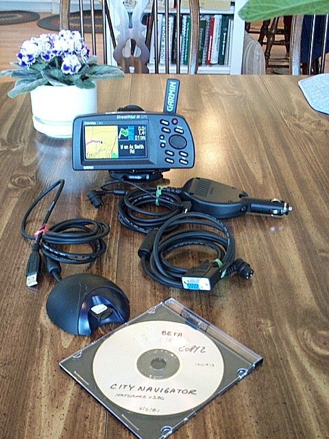
StreetPilot III Kit
.
StreetPilot III Kit
More StreetPilot III Photographs
The Garmin ColorMap StreetPilot III is in Garmin's fifth generation of GPS receivers with street level mapping. It is their first model with a) AUTOMATIC ADDRESS-TO-ADDRESS ROUTING (A2A) and VOICE COMMAND OUTPUT (VCO). With this unit and a copy of Garmin's (NavTech derived) CityNavigator mapping program a user will have the most detailed highway and residential street level maps available for the USA today. The USA coverage area for NavTech maps (version 4.01) is the entire USA plus a bit of Canada. The SP-III allows a user to automatically route using both the CityNavigator maps and/or the Base Map. Thus, with a "routable base map", you can automatically route from an address in New York City to San Francisco with only CityNavigator map sections for NYC and SFO loaded. The base map will provide information (and "road lock") for all highway routing between metro areas. SP-III is the only autorouting system that I am aware of that can do this sort of intercity routing without the need to load intermediate maps as you go from one NavTech region to another. (There are 10 NavTech regions in the USA and Canada combined.) Priced at about $850, (Check Latest Prices Here.) SP-III is the lowest priced Automatic Car Navigator -and- One of the best performers.
We think the ColorMap StreetPilot III Ver. 2.10 is a "break-through" in portable (move from car to car easily) address-to-address automatic routing GPS car navigation systems. It was designed from the ground up to economically replace the combination of GPS/Laptop Computer/Mapping Software system that many of us use to maneuver around cities in the USA (SP-III CityNavigator automatic routing maps only available for the USA, Europe and Australia as of January 2002). SP-III includes a set of "base maps" showing all state and federal highways and major thoroughfares in towns and cities throughout the USA. In addition, SP-III can be loaded with optional RESIDENTIAL street level detail maps of any USA area and a variety of overseas locations including much of Europe and cities in Australia. By using map memory cartridges uploaded with data from Garmin's CityNavigator, MetroGuide and MapSource CDROM map systems the system can economically be used over a wide geographical area. These include: CityNavigator (NavTech Maps, the best GPS routable maps available in areas covered), MapSource MetroGuide (Etak Maps, good maps but not quite as up to date as NavTech and only USA version has autorouting capability within SP-III), Roads & Recreation, USA Topo, and WorldMap CD ROMs. 8, 16, 32, 64, and 128 megabyte memory cartridges are available. (Our recommended minimum size is 32megs which is the size that comes bundled with the SP-III kit. However, the 128meg memory module comes standard with the "Deluxe" kit and we like this size even better.) The StreetPilot III is straightforward to use but the manual leaves some gaps that can be filled by a number of tutorial videos and CDs available from GPS vendors.
NOTE: The amount of up-to-date detail on CityNavigator maps as compared to MapSource USA maps seems to depend on where you are. See a few examples (HERE).
The CityNavigator (NavTech) map offering is necessary for the Automatic Address-to-Address routing to work to street address level. We have reviewed the VDO Dayton, and the Datus RouteFinder A2A/VCO systems previously and have used the Magellan 750Nav units. The SP-III provides automated guidance on a par with any of these and in fact much more routinely gives routing "the same as I would have chosen". Sometimes the route chosen is "just OK", but after all, SP-III is just a machine. The downside for SP-III as compared to the $3000 models is that most of the more expensive models have some sort of "dead reckoning" capability to permit navigation to continue for short intervals when signals are lost. Such signal loss can happen in "city canyons" such as NYC and LA where high rise buildings can block the satellite signals.
As to CityNavigator map sizes, the four central Atlanta "map chunks" are about 1.5 megabytes each, and other area "map chunks" range from 400 kbytes to 2.0 mbytes. To see EXACTLY what CityNavigator maps look like for YOUR area, click HERE and select CityNavigator on the map viewer. Keep clicking on the map until you get your area in whatever detail you want. You can route to covered highway intersections just using the basemap.
Automatic ROUTE GENERATION with SP is pretty fast. It usually takes less than a minute to generate a route within the Atlanta area. One trial route from Atlanta to an address in Los Angeles took about 2 minutes which seems quite satisfactory.
CityNavigator and MapSource 4.xx offer the user a new (for Garmin) capability of generating a route automatically ON THE PC as well as within the SP-III. This permits users to generate a series of automatically generated routes and load these into other Garmin GPS receivers as well as the SP-III. The CityNavigator (NavTech) maps offer coverage of the covered USA Metro Areas with superior road detail. Details as to which lane to be in and which way to turn onto exit ramps at complex expressway interchanges is included. It is still not possible to track your progress using NMEA output via MapSource as you can using StreetAtlas 8/9/2003 and similar programs.
While CityNavigator has "city area map chunks" ranging from about 23kbytes to 2 mbytes, MetroGuide II also has max 2 MB "chunks" (compared to the older MetroGuide version with 8MB max chunks) whereas the Roads & Recreation Maps typically load "county size hunks" which typically use 100K to 400K bytes of memory per county. In the Atlanta area, the coverage area for a selected 8 MB MetroGuide or CityNavigator map section is roughly a square about 125 miles on a side. This covers the formal "Atlanta Metropolitan Area" and then some. Using the less accurate (but still very good) MapSource R&R maps, you are able to include a much larger area and up to 99 "counties" in an 8 meg memory cartridge. (See the MapSource Product Information for more detail.) Note: As of this date, NO OTHER map products (from alternative vendors) can be uploaded into Garmin GPS receivers except those offered by Garmin for the purpose. This same proprietary relationship exists for other vendor's consumer GPS products as well. The 128Meg map cartridge will typically cover two or more states but this varies with road density within a state.
This new SP-III is designed principally for automobile use and its size, the two hour (or so) battery life and lack of off road features make it unsuitable for hiking or boating use. NiMH rechargeable batteries give better service than alkaline.
What's new in StreetPilot III?
The SP-III DELUXE kit contains: SP-III GPS, 128meg memory, Speaker/power cable, USB memory loader, Dash Mount Bracket, CityNavigator CDROM, Manual, and a data cable for computer interconnect.
We can say that SP-III gets rid of almost ALL of the error effects of GPS error that bothers so many people. When you use CityNavigator or MetroGuide the SP-III will "lock" your vehicle track to roads and as long as you travel on the road. (This feature does not operate with MapSource R&R, USA Topo, or WorldMap.) Automatically generated routes using CityNavigator maps "rubber band" to the roads in the route. Once in a great while, you may find an isolated road segment where the map is so far off that road lock will jump off the road, but it is extremely rare.
Another useful feature is that with CityNavigator (and MetroGuide) maps, (when not in guidance mode) all approaching cross street names are displayed prior to arrival. We found the SP-III audio and visual guidance directions very satisfactory. SP-III automatically varies its "turn here" warning time to give you more warning time at high speed than at lower speed. A typical audio/visual sequence would go something like this:
An alternative screen shows a listing of turns to come. Another screen display is the trip computer.
AUTOZOOM zooms the screen in and out automatically as you approach waypoints and turns so you always have time to make decisions.
Route selections for CAR, TRUCK, BUS, and EMERGENCY are provided so you can be properly routed depending on your vehicle type.
The accessory CityNavigator and
MetroGuide Maps contain many thousands of
"attractions" on board. These include:
Food and drink, Lodging,
Attractions, Entertainment, Shopping, Services,
Transportation, and Emergency and Government. In
our area, there were a few restaurants we
had not known about (and a few
prominent ones are missing). The
restaurant listing appeared to be about 2 years old.
Listed "Attractions" include theme parks,
museums, libraries, schools, parks and
such. The listings were quite satisfactory
though the placement of a particular restaurant or
gas station might vary plus or
minus a few hundred feet (once, half a
mile) from the actual location.
This feature could be very handy in a strange city.
The user can give the GPS a Street Address
or Street Intersection or select one of the, for
instance, Restaurants in the accessory map data base
module and it will LOCATE this address or location automatically
and plot it on the map screen. The SP-III can then
automatically create a "turn-by-turn" route to this destination from
wherever you are. This is a very useful feature and it has worked
very well in our tests. Be prepared for a few well known items
(such as my local library) to be missing from the "attractions"
list. Still, if you are unfamiliar with an area, what
IS included will be quite useful.
Are 128 megabytes of MAP MEMORY enough?
We think the 128 megs is enough for "most" users. SP-III
has a map memory of 128megs available and also a "complete USA
basemap". The basemap has the entire USA included as far as major
roadways, state numbered roads and interstate highways are
concerned.
Then, if you need complete detail for a PARTICULAR city (or rural
area) you are going to visit, you can load (from your laptop or
other IBM type Personal Computer) high detail maps from
CityNavigator.
So.. If you are going from (say) Chicago to San Franscisco and
back to Miami with a stop in Denver, you would load detailed maps
for the four urban areas of interest and let the basemap be your guide
for other areas and still have lots of empty memory in your user map
cartridge for other areas. The unit automatically transitions
from the basemap to the detailed maps when the detailed maps are
available and back again as you move out of the detailed map
areas. While it is quite easy to load new maps from a laptop
computer into your SP-III, you could just have multiple map
cartridges and plug in a new (preloaded with maps) cartridge for
various areas if you did not have ready access to a computer on a
lengthy road trip.
SP-III does not have the 2Gigabyte map memory we all wish for, but it
is quite flexible and the basemap goes a long way toward making 128megs
of map memory sufficient for most users. That said, DO NOT
expect that the basemap is as accurate as the CityNavigator maps from
NavTech. There will be some areas where the map error is larger
than 150ft and the SP-III will think you are offroute and will claim it
must recalculate. This is a minor irratation for some people but
if you just ignore the problem when it (fairly rarely) occurs,
things work out fine.
What are the Technical
Specifications of the SP-III?
Specific Questions Answered:
We do not recommend SP for hiking or marine activities due to its reduced feature set optimized for automobile use.
The SP-III Prototype used for this review includes no basemaps outside the Western Hemisphere. I believe the production unit will have a rudimentary base map for the world. More on this later. The basemap has less detail in South America and no railroads, but more roads in Canada and Mexico. The basemap of the USA includes maps of USA interstate, national, primary and secondary state highways, cities, larger towns, waterways, rivers, and coastlines. (Note: See Garmin Base Maps description for more information on Base Map content.) Base Maps are included in the SP-III's internal memory while USER Uploadable Street Maps on CD ROM provide street level or topo detail of user selected areas which are loaded to the 32 meg or 64 or 128 meg memory cartridges. (Note: older 8 meg and 16 meg cartridges can also be used with SP-III.)
Additional SP features include:
The trip computer is improved and has functionality similar to the SP(CM). With SP-III, You will notice that when you come to a stop, the estimated times do not go to infinity, but hold a realistic value. The GPS calculates estimated times based upon road classes in your Route and modify the estimation by your actual speeds on the various road classes. It also computes the actual road distance between turns (waypoints) instead of using straight line distances. The results give fairly accurate estimated time to various points, even when using different road classes, like traveling on the freeway, and then exiting later on some local roads. Your estimates will not only be based upon your current highway speed, but by the combination of speeds you are using, or will be using on the various road classes.
The GPS has the standard HOST mode which allows the upload/download of waypoints, routes, tracks, etc., OR use the GPS for tracking with the NMEA output WITHOUT having to change from GARMIN to NMEA mode and vice versa. The SP external power/data cable and active antenna BNC connection is the same as for the G-III(+) and G-II(+) and earlier SPs..
Note: None of the "display fields" are user configurable in SP-III. A "satellite" page (menu/menu+GPS INFO) rounds out the active displays. Another display shows loaded maps and allows user selection of "active" maps. If you have multiple maps of the same area (a TOPO and CityNavigator for instance) you will want to turn off one or the other and use one at a time.
MetroGuide's Find-an-Address feature includes: Intersection, Place, Restaurant, Hotel, Entertainment capability. SP (CM) can find such places in the upload coverage area. Even a restaurant less than one year old were included. However, some of the locations of restaurants, hotels, etc. are misplaced by considerable distances.
A "Driving Status" line on the Map display indicates such information as "Driving South on Roswell Road near Sandy Springs". This can be quite useful in cities where you don't exactly know which street you are on. Also while driving, the name of each approaching side street is displayed allowing finding side streets in the dark.
Major features the StreetPilot DOES NOT have compared with G-III+
Datums- The SP only provides WGS-84 so any external mapping program which cannot use WGS-84 directly OR convert WGS-84 to its required datum will give larger than normal map position errors.
Battery timer- The SP has no battery timer feature. It does have a battery "fuel gauge" display and MORE IMPORTANT, SP-III has an "Automatic Shutdown when External Power is Removed" feature to prevent running down the internal batteries if you forget to turn off StreetPilot in your car. Unfortunately, it does NOT have automatic power ON when external power is applied like other Car Navigation systems.
43 ICONS are available in the SP-III to identify user waypoints and mark routes. The battery meter can be set to alkaline, or NiCad types. Alkaline battery life in the SP (6 AA cells) is about 2 hours.
Street pricing of the SP-III is about US $850 or less and includes: 32 meg memory cartridge, speaker/power cable CityNavigator CDROM and a password key for one (of 10) USA/Canada regions.
Features and Operation
The SP-III has a direct and easy to use routing system. The user:
The SP-III operates from 6 AA batteries or from external power in the range of 10 to 32 volts DC. The SP-III uses FLASH memory and has no memory backup battery. We get about 2 hours from a set of 6 Toshiba/Sony Alkaline AA cells. Best to keep the unit plugged into external power. The LED backlit display lighting has a rated design life of 100,000 hours. The SP shuts down when the internal battery voltage goes below 4.8 (alkaline) or 5.2 (NiCad) volts unless external power is applied.
A special Power/Speaker cable is supplied with SP-III. However, the data/power cable used is the same as the Garmin G-45/12/II+/G-III+ and other SP units. Normally, you would not need a DATA cable if you use the USB module to load maps into your SP-III. However, you will need a data cable if you intend to upload/download routes/tracks/waypoints directly to MapSource or to other 3rd Party Software.
The external antenna connector, a BNC coax jack, is located on the right rear of the unit just behind the keys. The BNC jack is powered and has a current limit rated at 50 ma to protect the unit from shorts on the antenna cable. However, the standard antenna is passive. The Garmin GA-26 amplified antenna, Lowe's, Tri-M, and the MAGELLAN M-4000 amplified antenna all work with the SP. We believe most other amplified GPS antennas will work as well.
The SP-III outputs out only the NMEA protocol NMEA-0183 ver 2.0 and accepts RTCM-0104. Other proprietary GARMIN sentences are input/output as well. Garmin has included its (now) standard HOST MODE (Called GARMIN in the GPS) so that (with suitable software commands) it is now possible to switch from NMEA to up/download without manual intervention. The NMEA out, TEXT out, DGPS in, and RTCM in are also available.
DGPS signals in the RTCM-0104 format are accepted. Anytime NMEA output is selected, the baud rate of the output serial port is set to 4800 baud and input is disabled or it can be set for RTCM in and NMEA out. RTCM (DGPS) alone can use baud rates of 300 to 9600. A setup screen permits selection of the I/O combination needed by a particular application.
Operating temperature range is specified as -15C to +70C. Unique in their class, Like other Garmin handheld GPS receivers, SP is rated submersible to one meter per IEC529 IPX(7). The maximum altitude rating is 60,000ft and speed maximum is 999 knots.
Master Reset:
Hold down the quit button, route button, and
up on the rocker pad. Press power button, wait until you get the first
power-up screen then let go of the up and wait
for the unit to come on fully then let go of the rest of the buttons.
Feature Details:
I have tested the SP on the roads and highways of North Georgia including several interstate trips. Our SP has worked properly at all times as far as we could tell. We tried uploading and downloading waypoints, tracks and routes using G7ToWin. We tried it out on SA5, 6, and 7, Precision Mapping 3, Vista, AutoRoute 5. Generally tracking worked well, and SA7 upload/download functions worked OK. (However, most upload/download programs will require later releases for all of the new SP functions to upload/download properly. Examples: 50 icons, One 10 character names, commands to use Garmin's new "no touch" switch over from NMEA to UPLOAD/DOWNLOAD. All map programs tested which specified a NMEA-0183 ver 2.0 data stream as input tracked properly with the SP.
We compared the SP with the G-12XL, G-III+, G-II+ and the EEx2. The SP performed on a par with all units in every test for lock stability, multipath performance, re-lock after an underpass, and ability to suddenly change direction without loss of lock. The SP laid down smooth tracks on our highway maps during all tests. No gaps, jumps, etc., (The SP has data smoothing like the G-III+.)
We noted that all SP models and G-III+ (along with the G-12XL and the G-II+) have a form of "dead reckoning" for moments when signal dropouts occur. For instance, if the SP-III is tracking along and just before a sharp turn you invert it and block its antenna, it will continue to track straight for about 30 seconds. It also provides a very good data smoothing filter to throw out random fixes that are way off track. This results in an exceptionally smooth track on a moving map display even with the "road lock" option turned off. Even with this filter, there was no overshoot apparent during quick stops, sharp turns, and similar maneuvers when normal continuous tracking was taking place.
SP-III performance under tree cover and city canyon conditions was about the same as the earlier SPs, G-III+, G-II+, G-12XL and the EEx2 and we rate that as very good.
We found the display controls easy to learn and use. The menu system and arrangement is quite satisfactory. (No manual was available at the time of the review so we may have missed a few features). The SPIII has many feature changes as compared with the older SPs and other handheld units. However, after a couple of hours of operation, we found the SP-III menu system both adequate and easy to use.
Since the SP-III, SP, G-III+, G-12XL and the G-II+ exhibited essentially identical tracking performance in our tests, we did not perform the extensive field trials we made with the G-12XL, EE, and others. For more information on tracking results with our testing of the G-12XL, and the G-II+, etc., see our reviews at: http://gpsinformation.net
Summary
Our overall impressions are that the StreetPilot III is a new generation of low cost Automobile Navigation Systems. With the lowest price of any truly automatic self contained address-to-address car navigation system and the superior NavTech street maps, we consider the SP-III to be revolutionary in its price class. With the SP-III, I believe we can eliminate having to use paper maps for car navigation (in the covered areas).
What DON'T we like about
the StreetPilot III?
1) The unit drains batteries extremely
rapidly. It will be extremely advantageous to operate it
from external power. This problem is mitigated by the
"automatic shutdown when external power is
removed" feature.
2) The CityNavigator software for "all" or one
of ten regions of the USA comes bundled with SP-III depending on the kit
selected. An individual additional region cost about $99 and the
bundle with "all the rest" of the USA costs about $200 or
so. Many will opt right away for the "entire
USA". This is a bit pricey for many buyers, BUT> it
is the best car navigation map system that you can buy and Garmin's
price is considerably less than other car navigation vendors
charge for the same map capability. These are apparently the same
maps that are used in the $2000/$3000 car navigation systems.
3) The simulator is a bit hard to steer and
gets off track now and then, but this is "picky".
4) We would like to see the SP-III power up
automatically when external power is applied.
5) On occasion, we see the router
generate "funny routes" such as taking a busy numbered federal highway
instead of a nearby freeway. All Car Navigation routers we have
used seem to do this from time to time and so I guess it is "just the
state of the present art".
Which GPS do I use now when I go on automobile trips? The StreetPilot III. Would I take it hiking or boating? No.
If anyone has any additions, questions, suggestions, error corrections other comments, please feel free to Email.