Review by Joe Mehaffey and Jack Yeazel
Revision: 26 July. 2002 (Add manual route generation)
Return to GPS General Information Home Page
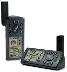
Portrait or Landscape Display
GPS-V Deluxe: How is it different from
the "old" GPS-V and accessories?
Answer: Not by much. The GPS-V
deluxe
is simply a repackaged GPS-V with bundled accessories.
Accessories
include: Copy of the NEW edition of CitySelect, Data
Cable,
Lanyard, Manual, and UNLOCK ALL codes for CitySelect.
The prices quoted are similar to the old prices with all
accessories,
but get multiple quotes from various dealers as prices do vary.
If
you bought the "Old" version after April 2002, you are entitled
to
a special deal from Garmin on the new map program and unlock all code
so
you are not in financial jeopardy no matter which you buy. As of
December 2004, we feel the GPS-V is now outdated and is superseded
-FOR CAR NAVIGATION USE- by many new and more capable units
with larger map memories even though GPS-V is still available.
Still, for a mix of marine, hiking, and car navigation, you may find
the GPS-V just the thing for YOU. See our article, MY FIRST GPS FOR CAR NAVIGATION for our recommended units. One interesting unit to look at is the Garmin Quest.
OVERVIEW:
Consumer GPS technology continues to move forward with the introduction
of the Garmin GPS-V 12 channel parallel GPS receiver. This product
introduces automatic present-position-to-address
or feature routing and WAAS
in a small handheld GPSR similar in size and capability to
the G-III+. With automatic routing, users can input the address
or waypoint of a destination and the G-V will compute a route and give
turn-by-turn instructions as the route is navigated. The GPS
provides a moving cursor on the moving map showing your position on the
GPSR's internal map. As a turn approaches, the map switches to a
track-up display to aid in the visualization of the needed turn.
Two warnings are sounded prior to the turn.
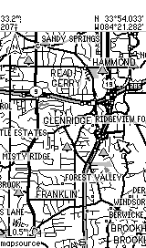
The G-V comes with "CitySelect" (NavTech-based maps). This software is similar to "CityNavigator" software furnished with the StreetPilot III. CitySelect has the same excellent (but not perfect) maps, but routing information has been slightly modified for the lower processor power of the G-V. The CitySelect user can enable one of about 9 USA regions at no charge and can enable some or all of the others at additional cost. The G-V has map memory of about 19 megabytes. Memory is not expandable. The G-V will NOT accept memory cartridges. Street Prices are approximately $415US. Check Discount prices (HERE).
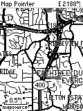
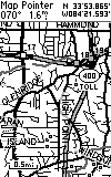
In the Atlanta area, this 19 megs will hold approximately the northern 1/3 of Georgia including Atlanta. The "map chunks" loaded do NOT need to be contiguous. The G-V can also be loaded with maps from any of Garmin's consumer map offerings such as MetroGuide USA (which provides automatic guidance USA wide), R&R, TOPO, and Worldmap. Note: The G-V contains a base map which contains all of the major federal and state highways of the USA and Canada. The G-V can perform automatic routing on the basemap as well as using either CS or MG USA maps for this purpose. Thus, the user can load detailed maps for (say) Atlanta and Denver. Then have G-V generate a route to an address in Denver from Atlanta. The G-V will use the CS (or MG USA) map at the beginning and end of the route and the base map along the way. This eliminates the need to load CS (or other detailed) maps for the highway portions of most journeys. NOTE: The basemap in the GPS-V comes in multiple versions depending on the part of the world the GPS-V is sold into. The base map CANNOT be changed and so if you <for instance> buy a USA unit and use it in Europe, you will have to load CitySelect maps into the G-V for all areas you intend to navigate as the USA version basemap has little detail for any part of the world except the USA and Canada.
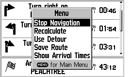
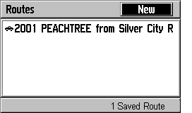
The G-V has, for the first time in a small handheld GPS receiver, the ability to generate an AUTOMATIC route from your current location to another point. The destination point can be any of: an address, waypoint, road intersection, city or town, highway exit, Point of Interest from the internal list, or Recently Found Places. This extremely flexible system is easy to operate and works quite well. ANY automatically-generated route can be saved from the Turn-by-Turn page.
It is possible to generate a route internal to the G-V from any destination other than your current location, PROVIDED you are in the Simulator mode and use the New Location feature from the Satellite Page. Routes can also be generated from within MapSource and uploaded to the unit. NOTE: With Ver. 2.04, the number of Via Points has been increased to 100 and routepoints to 50. If Offroad Recalculation is ON, the GPS will immediately recalculate the route from present position. If one turns this feature OFF, then the route is preserved in the GPS, so that you can manually follow the pre-planned route and still get the "pop up" guidance screens.
The current routing systems available cannot know traffic conditions or detailed road conditions and so they will not always be able to take local conditions into account when generating a route. When using CitySelect, the routes are almost always in the "very good" class and almost as high a quality as StreetPilot III using CityNavigator map data. (Note: By "high quality", We mean: the route was the one we would have chosen, or the route was (almost) as good as the one we would have chosen, or the route was efficient, direct, and without problems, but was not exactly the route one would have chosen for themselves being familiar with the area.) With MetroGuide USA maps loaded, the automatically generated routes are less precise and sometimes they are obviously not the best. BUT, MG-USA covers the entire USA as opposed to the 120 largest metro areas for CitySelect
HOW DOES THE USER INPUT A ROUTE REQUEST TO THE GPS-V?
A) The ON ROAD mode of operation.
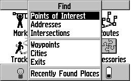
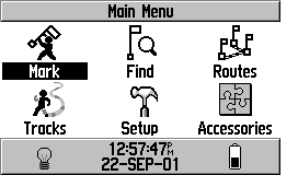
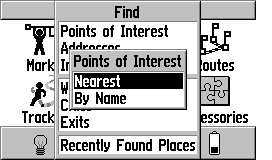
The process starts with the pressing of the FIND key on the front
of the G-V. Alternatively, you can select FIND on the main
menu. Then you will see this screen:
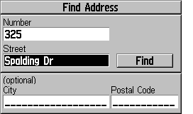
Select ADDRESSES+ENTER gives:
Then Enter an ADDRESS gives:
 Click
HERE for MORE Routing Screens
Click
HERE for MORE Routing Screens
Note: In addition to Addresses, you
can request routes to POI, Intersections, Waypoints, Cities,
Expressway Exits and Recently found places.
Routing Notes:
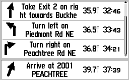
1) The turn screens "pop up" as a turn is approached
and return to the normal map screen as you pass the turn.
2) The user can select either NORTH UP or TRACK
UP for the main map, but the pop-up screens are always TRACK UP.
3) If you fail to follow the directions,
the GPS will automatically recalculate a new route as soon as it realizes
you are "off route".
4) If you stop at (say) a restaurant, when
you return and restart the GPS, it will automatically recalculate
and take you on the rest of your route.
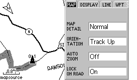
5) "Road Routing" is the default. If you
want to use the G-V on a hiking adventure, you must select the OFF
ROAD option in MAP SETUP (go to MAP page and press MENU, on MAP tab, turn
LOCK ON ROAD to OFF) or the G-V will try and route you from waypoint to
waypoint using nearby roads. ALSO: You must select OFF ROAD
in ROUTE PREFERENCES in the ROUTING SETUP tab in the MAP SETUP menu.
6) Faster Time seems to always give me better
automatically generated routes than the Shorter Distance option.
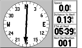
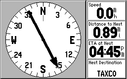
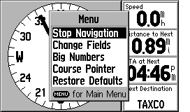
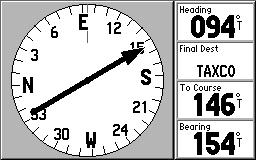
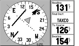
B) The OFF ROAD mode of operation
As noted in item #5 immediately above, you must select the
OFF ROAD mode of operation. This mode is used for hiking activities.
In this mode, the routes do NOT lock to roads and the compass page
is changed in format to the same as used in the G-III PLUS and other general
purpose Garmin GPS units.
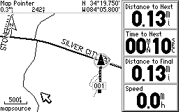
Route from
road to 001:
The Turn-by-Turn Text Guidance Screen changes to the Pointer screen:
 .............
...
.............
...
Moving the cursor will display Lon/Lat of the pointer, Quit returns
to normal mode.
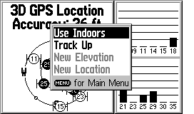
MANUAL ROUTE GENERATION:
Garmin supplied this solution: Put the unit in simulator mode
and then on that same satellite page press the menu button again and scroll
down to new location and press enter. Then choose the option of use map
and press enter on it. The next thing you will do is to move the pointer
on the screen with your rocker pad to where you want the unit to think
is your current location or starting point. Then press the find button
on your unit and enter the destination you wish to route to. The
unit will create a route from that starting point to the destination you
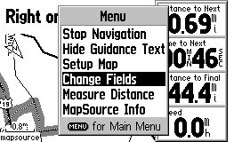
set it to. Page over to the Turn-by-turn page, press MENU, and then
Save Route. One can then use Automatic Route Recalculation ON or
OFF to get the desired routing instructions.
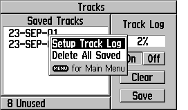
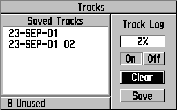
TRACKLOGS: The tracklog capacity is 3,000 trackpoints with 10 saved tracks of 250 trackpoints. The Auto tracklog resolution can be set to Highest, High, Medium, Low, or Lowest. In the Highest setting, the tracklogs are as detailed as any Garmin GPS. With WAAS, this unit is well suited for placing or recovery of Geocached objects. It has no trouble, with a few minutes averaging in the clear, to establish a reference point within 3 meters.
 ......
 ......
G-V
Screen
eMap
Screen
G-III+ Screen
Note: Above pictures are NOT to scale but show the different screen resolutions of the three models. The pixel count of the G-V screen is 160x256 and the eMap is 120x160 and that is reflected in the above pictures. The actual size of the G-V screen is approximately 1.5"x 2.2" which is same as the G-III+ shown on the right with its 100x160 pixel display.
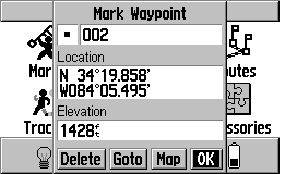
WAYPOINTS:
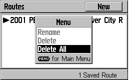
In order to delete ALL waypoints at once, press: Menu, Menu, Find,
Waypoints, By Name, Page, Menu, Delete All.
FEATURES of the GPS-V
We are going to try something new in explaining the features of the GPS-V. The number of option screens is quite large and the some features are somewhat obscure and difficult to find. Therefore, we are going to show screen photos of most of the GPS-V's operational screens and this will (hopefully) give a feature overview without too many words. (Please let us know if you like/don't like this new approach and if you have additional questions, please eMail us.) (Note: The screen shots below are SLIGHTLY LARGER than the actual 2.2"W x 1.5"H (5.6 x 3.8 cm), 256 x 160 pixels size. Attempts to scale the images produced distortion so we left them as is.)
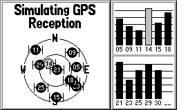
Satellite
Page
Pressing Menu on Sat Page Gives:
 Click
for MORE
Click
for MORE
 Click
for MORE
Click
for MORE
 .............
 Click
HERE for MORE
Click
HERE for MORE
 Click HERE for more
 Click
HERE for MORE
Click
HERE for MORE
HOW DOES THE G-V DIFFER FROM THE G-III PLUS? (Not
an exhaustive listing)
1) Higher resolution screen.
2) Automatic address to address routing is available using the basemap,
CitySelect or MetroGuide USA maps.
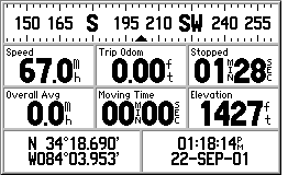
3) There is no formal TRIP COMPUTER page, but you have access
to all of the variables by selections on the COMPASS page.
4) The G-V has WAAS augmentation capability.
5) The G-V has an audio BEEP for alarms, messages, and
routing alerts.
6) The G-V "times out to operation" and does not require that you
press the ENTER key to get operational.
7) The G-V has an alkaline and Lithium battery selection.
(Do NOT ask me why they deleted NiCad and added Lithium instead of NiMH!)
8) The G-V has a proximity waypoint Alarm (with separate waypoint
list) and an ANCHOR DRAG alarm.
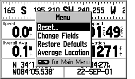
9) The G-V has waypoint averaging hidden. Go to Position page
and press MENU, select Average Location.
10) The G-V has "road lock" (cursor locks to the road even if map
and current position differ slightly).
11) The G-V has "route rubberbanding to roads"
(routes generated by address to address routing lock to roads instead of
being straight lines between turn points).
12) The G-V has automatic daylight savings time (but not automatic
time zone selection) for the USA only.
13) The G-V has automatic or prompted off route recalculation capability.
14) The G-V has an area calculating feature, but you have
to hunt for it. To use it, you a) clear the tracklog and b)
go hike around an area and c) go to TRACKLOGS in the main menu and d) save
the ENTIRE tracklog. When you do this, you will be shown a
screen which has the area bounded by the track. You can also select
one of the saved tracks and find the area as well. This is where
you find the TRACKBACK feature as well.
The G-V is by far the least expensive AUTOMATIC address to address GPS receiver available. It is the only truly "handheld" unit available. Other solutions such as the SP-III, and various handheld palm computer products (Magellan Companion and Raco Destinator for example) offer larger (and optionally color) screens at overall higher prices. Compared with any of the other available equipment, the G-V is a general purpose unit equally at home hiking or on the highway. The "ON ROAD" option provides good highway and road guidance with specialized screens. The "OFF ROAD" mode provides the standard Garmin circular compass display that we like for hiking use and other G-V features make the unit quite suitable for hiking activities as well as on the highway use.
We found the battery life quite satisfactory, but not quite as long (on a per AA cell basis) as other less capable units. We suspect that the automatic routing capabilities take a bit more computer power than units without this feature require. We found the G-V equally robust as compared with the G-III + and it is rated waterproof to IPX-7. Some have expressed concern about the G-III+ as to the robustness of the rotateable antenna. We do not share these concerns. While it is possible to break anything, the G-V antenna is sturdy and we have had no problems with any of the several GPSRs we have which are constructed similarly.
We do like the G-V's capability of rotating the screen to the vertical or to the horizontal at the touch of the Page button. We like the screen horizontal for car use and vertical when we carry it around as a pedestrian. Overall, we think the G-V is a very capable unit and Garmin has not left out features which would limit functionality for the hiker or motorist.
WHAT DO WE NOT LIKE ABOUT THE G-V?
There is not a lot to complain about with the G-V. It packs
a lot of functionality in a small package. But:
1) Deleting all waypoints requires an unusually high number (8 or
more) keystrokes.
2) We wish the G-V had a map cartridge capability.
3) For Car Navigation guidance, the spoken cues of the SP-III
are missed. (How quickly we are spoiled!)
For questions about the G-V hardware or mapping software, eMail JOE or JACK