 .
.
.
.  .
.
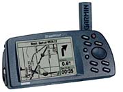
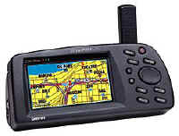
StreetPilot StreetPilot ColorMap
. .
. .
StreetPilot
StreetPilot ColorMap
NOTE: The StreetPilot and StreetPilot Color Map DO NOT offer internal (Automatically generated) Present Position to Address routing as is provided in the more recent StreetPilot III and GPS-V units. The below comments reflect the SP and SPCM as of Summer 2000 and comparisons do not reflect more recent GPS equipment.
When most people get their first GPS receiver, they ask, "Where's the MAP?" Garmin first put a highway map in the GPSMAP-175 (et al) and then into the G-III+ in 1999. The maps in these earlier units were not what most people wanted in their GPS designed for use in their automobiles. With the introduction of the new 12 channel parallel StreetPilot (SP) road mapping GPS system, Garmin has changed all that.
The StreetPilot (SP) Ver. 2.07 and StreetPilot ColorMap (SP CM) Ver. 2.09 are NEW KINDS of GPS receiver system. Maybe it can even be called a "break-through". It was designed from the ground up to replace the combination of GPS/Laptop Computer/Mapping Software system that many of us use to maneuver around cities in the USA (only USA at present, Europe in 2000). SP includes a set of "base maps" showing all state and federal highways and major thoroughfares in towns and cities. In addition, SP (CM) can be loaded with optional RESIDENTIAL street-level detail maps of major USA metropolitan areas using map memory cartridges uploaded with data from Garmin's MetroGuide and MapSource CDROM map systems. These include: MapSource MetroGuide (Etak Maps, the best available), Roads & Recreation, USA Topo, and WorldMap CD ROMs. 8 MB and 16 MB memory cartridges are available. Up to 50 "map chunks" can be loaded into a StreetPilot or SPCM at one time.
These maps offer coverage of the entire USA with superior road detail. Metroguide has map sections in 8 MB "hunks" whereas the Roads & Recreation Maps typically load "county size hunks" which typically use 100K to 400K bytes of memory per county. In the Atlanta area, the coverage area for a selected 8 MB ETAK map section is roughly a square about 125 miles on a side. This covers the formal "Atlanta Metropolitan Area" and then some. Using the less accurate (but still very good) MapSource R&R maps, you are able to include a much larger area and up to 50 "counties" in an 8 meg memory cartridge. (See the MapSource Product Information for more detail.) Note: As of this date, NO OTHER map products (from alternative vendors) can be uploaded into Garmin GPS receivers except those offered by Garmin for the purpose. This same proprietary relationship exists for other vendor's GPS products as well.
What's new in StreetPilot(CM)?
We can say that SP (CM) gets RID of almost ALL of the effects of Selective Availability (SA) that used to bother so many people. You can option to "lock" your vehicle track to roads and as long as you travel on the road, the combination of the accurate ETAK maps and Garmin's "Road Lock" feature keeps your trace where you want it. On the road! (This feature does not operate with MapSource R&R, USA Topo, or WorldMap.) When you make up a new route using the MapSource program with a MetroGuide map, it's interesting to see the new route "rubber band" itself to the shape of the road or highway as you input the "TURNS" (waypoints). With this new feature, the GPS pointer "knows" where it is going at every instant and does not simply point at the next waypoint which may be many miles away along a curvy road!
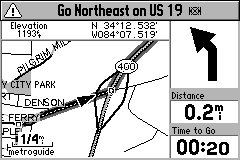
Another useful feature is that with ETAK, all approaching cross street names are displayed prior to arrival. We found the SP (CM)'s guidance directions very satisfactory. SP (CM) automatically varies its "turn here" warning time to give you a 30 seconds (user adjustable) warning of an upcoming turn regardless of your speed. The turn indication is a "BEEP-BEEP" and a LARGE ARROW indicates the direction of the next turn. Exceeding a 'Maximum Speed' also sounds the beep. AUTOZOOM zooms the screen in and out automatically as you approach waypoints and turns so you always have time to make decisions. The keys are lighted for night viewing.
The accessory MetroGuide Maps contain thousands of "attractions" on board. In our area, there were a few restaurants we had not known about (and a few prominent ones are missing). Listed "Attractions" include, restaurants, hotels/motels, entertainment, shopping areas, services, and tourist attractions. The listings were quite satisfactory though the placement of a particular restaurant or gas station might vary plus or minus a few hundred feet (once, half a mile) from the actual location. This feature could be very handy in a strange city.
The user can give the GPS a Street Address or Street Intersection or select one of the, for instance, Restaurants in the accessory map data base module and it will LOCATE this address or location automatically and plot it on the map screen. The SP (CM) will create a straight line from your present position (or some other starting point) and then you can "drag" this line over to various intersections until it describes completely the route you want to take from your starting point to the restaurant. From that point on, the GPS will direct you to your destination. This feature has worked well in tests.
The user can create a ROUTE using Street Atlas 5, 6, or 7 (which has map coverage of the entire USA) and upload this route into the SP (CM). The GPS will then direct you along the Street Atlas-calculated route. This feature worked imperfectly at times as Street Atlas maps are considerably less accurate than the ETAK maps. The divergence between maps can, at times, be enough to cause the "rubber band" feature to not lock onto the street. Still, this is a useful feature, and you can manually "rubber band" waypoints, so the route will track back onto the road if you wish. This feature has been improved by Garmin and early purchasers may wish to update their firmware at: Garmin Support Download Site
What's different between the SP and the SP CM?
The SP display is the same size as the larger GPSMAP-175, but is improved with 4 shades of gray, 240x160 pixels (size 3.5"x2.5") with a new 11-level orange backlighting system with higher brightness capability to accommodate the varying illumination needs of automotive use. The SP CM color display is slightly smaller with 16 colors and 240x128 pixels. The SP only uploads MapSource maps at 38,400 baud while the SP CM uploads them at 115,200 baud.
news:sci.geo.satellite-nav members have complained about not having the AUTOMATIC Daylight Savings Time in other GPS receivers. SP CM now HAS it! The GPS has a new algorithm for computing "time to go". Previous GARMIN units calculated estimated time to waypoints using a simple distance/speed calculation. This resulted in your ETA climbing up and down based upon your speed, and when you would stop, ETA would go to infinity and then "dash out".
With SP (CM), You will notice that when you come to a stop, the estimated times do not go to infinity, but hold a realistic value. The GPS calculates estimated times based upon road classes in your Route and modify the estimation by your actual speeds on the various road classes. It also computes the actual road distance between turns (waypoints) instead of using straight line distances. The results give accurate estimated time to various points, even when using different road classes, like traveling on the freeway, and then exiting later on some local roads. Your estimates will not only be based upon your current highway speed, but by the combination of speeds you are using, or will be using on the various road classes.
The GPS has a HOST mode which allows the upload/download of waypoints, routes, tracks, etc., OR use the GPS for tracking with the NMEA output WITHOUT having to change from GARMIN to NMEA mode and vice versa. The SP external power/data cable and active antenna BNC connection is the same as for the G-III(+) and G-II(+).
StreetPilot Feature and Function Highlights
The SP is packaged in a considerably larger case as compared with the GPS-III but uses the same shape. The overall case size is 3.2"h x 6.8"L x 2.2"d which can be laid flat and viewed normally. Six AA cells power the unit for about 16 hours (we got about 13 hours with Sony Alkalines) and from 4.5 to 7 hours with the back light on full time depending on brightness. (Note: The assumption is that the SP will be operated mostly on external power.) While a Garmin GPS feels "familiar" to the user, the differences between the SP (CM) and other GPS units are substantial. This GPS provides many (but not all) of the usual Garmin G-III+ features as a base, but the user interface has been extensively redesigned with great emphasis on automobile use. We do not recommend SP for hiking or marine activities due to its reduced feature set optimized for automobile use.
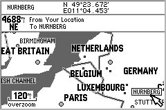
The SP (CM) includes the G-III+'s Overview Map of the World. However, the basemap has less detail in South America and no railroads, but more roads in Canada and Mexico plus maps of USA interstate, national, primary and secondary state highways, cities, larger towns, waterways, rivers, and coastlines. (Note: See Garmin Base Maps description for more information on Base Map content.) Base Maps are included in the SP (CM)'s internal memory while USER Uploadable Street Maps on CD ROM provide street level or topo detail of user selected areas which can be uploaded to an optional 8 MB or 16 MB memory cartridge.
Additional SP features beyond the G-III+ include:
A new "dashboard" page provides a display of 9 items which are speed, distance traveled, battery condition, average speed while moving, average speed on trip, maximum speed, driving time, stopped time, and total time on trip. A "Road Sign Page" gives the driver directions during automated navigation. An enlarged "map page" similar to the G-III+ displays the desired map area. Note: None of the "display fields" are user configurable in SP. A "satellite" page (which alternates with the dashboard page) rounds out the active displays.
MetroGuide's Find-an-Address includes: Intersection, Place, Restaurant, Hotel, Entertainment capability. SP (CM) can find such places in the upload coverage area. Even a restaurant less than one year old were included. However, some of the locations of restaurants, hotels, etc. are misplaced by considerable distances.
A "Driving Status" line on the Map display indicates such information as "Driving South on Roswell Road near Sandy Springs". This can be quite useful in cities where you don't exactly know which street you are on. Also while driving, the name of each approaching side street is displayed allowing finding side streets in the dark.
Major features the StreetPilot DOES NOT have compared with G-III+
Datums- The SP only provides WGS-84 so any external mapping program which cannot use WGS-84 directly OR convert WGS-84 to its required datum will give larger than normal map position errors.
Waypoints- The SP provides only 100 user Waypoints as compared with 500 in the SP CM. The SP routes use none of these when routes are uploaded from StreetAtlas, so the waypoint count isn't increased.
Battery timer- The SP has no battery timer feature. It does have a battery "fuel gauge" display and MORE IMPORTANT, SP now has an "Automatic Shutdown when External Power is Removed" feature to prevent running down the internal batteries if you forget to turn off StreetPilot in your car.
Fifty ICONS are available in the SP to identify user waypoints and mark routes. A one inch diameter calibrated compass rose page provides bearing, course and other information. The battery meter can be set to alkaline, or NiCad types. Alkaline battery life in the SP (6 AA cells) is about 16 hours compared with about 2.5 hours for the SP CM. (This is about halved if normal 50% backlighting is run continuously.)
Street pricing of the SP is about US $390and the SP CM about $545 as of June 2000.
Features and Operation
Basic functions in the SP are similar
to those in the G-III+, but many functions are
quite differently due to the design being optimized for Automotive
use. The SP incorporates the same 12 channel PARALLEL
GPS receiver design used in the G-12XL/G-II+/G-III+ products.
Like these, the SP locks on to the SV signals quickly.
"Warm starts" are typical in 20 seconds.
(The prototype unit I reviewed is said not to be as fast to
lock as production units.) "Cold Starts"
after 3 hours off time take 50 to
70 seconds. In AutoLocate after a 1000 mile
UPS trip, the G3 locked on in less than five minutes.
Specifications are "warm start" , 15
seconds, "cold start" 45 seconds,
"AutoLocate" 5 minutes. These times are typical
of 12 channel parallel receivers in the clear
and not moving, but a bit slower than the G-II+
in our measurements. If the SP is shielded from SVs (and thus
unable to lock) for a time, the unit will request
initialization. With Garmin's "Initialize
by Map" feature, you do
not need your approximate lon/lat to speed
up the initial lock when you move more than
300 miles with the unit off. Simply point
at your approximate location on the map and press
"enter". If you "don't want to mess with
it", you can select AutoLocate and it will
figure out where it is in minutes all by itself. In a
moving vehicle, expect lock times to be longer due to
flutter and multipath on
the GPS signal.
The SP's specification for position accuracy is 100 meters with SA (Good DOP), 15 meters exclusive of SA and 5 meters with suitable DGPS correction signals. These are the same as the G-12XL, G-II+ and the G3. This specification is typical of Garmin's 12 channel equipment line. The SP (and G-III+) appear to have enhanced position and velocity filtering as compared with the G-12XL/G-II+ as a result of improved the data filtering algorithms. We notice more directional stability in the compass display when walking as well as somewhat less variation of indicated velocity. (Not that you would hike with a unit the size of the SP.) The SP has Garmin's "dead reckoning" feature which, upon loss of SV signals, will project a course for 30 seconds along the last valid heading. This reduces the impact of momentary loss of GPS signals at underpasses, tree cover, and city buildings.
Position averaging is NOT available in the SP. To improve accuracy, the SP (like other Garmin 12 channel units) uses an over determined solution when more than 4 SVs are locked. This produces somewhat higher accuracy than units which use only the best four SVs. Garmin uses an algorithm that "gives varying authority" to measurements from SVs depending on their geometry, and other factors. This may be responsible for the relatively good accuracy of Garmin's 12 channel parallel receivers.
The SP operates from 6 AA batteries or from external power in the range of 10 to 32 volts DC. External current draw at 12 volts input on our unit is about 100 ma (light off). Battery drain is about 128 ma (light off), 250 ma (light at 50%) and 350ma (light on bright). Memory backup power drawn from batteries when the unit is off is about 140 microamps. We get about 13 hours from a set of 6 Toshiba/Sony Alkaline AA cells. This battery life is about 130% of the G-III+, but with 6 cells instead of 4. Garmin says the extra power drawn is a result of the higher power requirements of the components used to support much larger high resolution display and the mapping functions of the unit. The LED backlit display lighting has a rated design life of 100,000 hours. The SP shuts down when the internal battery voltage goes below 4.8 (alkaline) or 5.2 (NiCad) volts.
The data/power cable used is the same as the Garmin G-45/12/II+/G-III+ units. The external antenna connector, a BNC coax jack, is located on the right rear of the unit just behind the keys. The BNC jack is powered and has a current limit rated at 50 ma to protect the unit from shorts on the antenna cable. However, the standard antenna is passive. (In our prototype unit, we found the current limit set to about 25 ma. Garmin assures us production units will deliver 50 ma.) The Garmin GA-26 amplified antenna, Lowe's, Tri-M, and the MAGELLAN M-4000 amplified antenna all work with the SP. We believe most other amplified GPS antennas will work as well.
The SP (CM) puts out only the NMEA protocol NMEA-0183 ver 2.0 and accepts RTCM-0104. Other proprietary GARMIN sentences are input/output as well. FINALLY! Garmin has included a new HOST MODE (Called Garmin Data Transfer in the GPS) so that (with suitable software commands) it is now possible to switch from NMEA to up/download without manual intervention. The old GRMN and NMEA modes are included for compatibility with older mapping software.
DGPS signals in the RTCM-0104 format are accepted. Anytime NMEA output is selected, the baud rate of both the input and output serial port is set to 4800 baud. RTCM (DGPS) alone can use baud rates of 300 to 9600. A setup screen permits selection of the I/O combination needed by a particular application.
Operating temperature range is specified as -15C to +70C. Unique in their class, Like other Garmin handheld GPS receivers, SP is rated submersible to one meter per IEC529 IPX(7). The maximum altitude rating is 60,000ft and speed maximum is 999 knots.
Feature Details
Jack Yeazel and I have tested the SP on the roads and highways of North Georgia including one interstate trip. Our SP has worked properly at all times as far as we could tell. We tried uploading and downloading waypoints, tracks and routes using G7ToWin. We tried it out on SA5, 6, and 7, Precision Mapping 3, Vista, AutoRoute 5. Generally tracking worked well, and SA7 upload/download functions worked OK. (However, most upload/download programs will require later releases for all of the new SP functions to upload/download properly. Examples: 50 icons, One 10 character names, commands to use Garmin's new "no touch" switch over from NMEA to UPLOAD/DOWNLOAD. All map programs tested which specified a NMEA-0183 ver 2.0 data stream as input tracked properly with the SP.
We compared the SP with the G-12XL, G-III+, G-II+ and the EEx2. The SP performed on a par with all units in every test for lock stability, multipath performance, re-lock after an underpass, and ability to suddenly change direction without loss of lock. The SP laid down smooth tracks on our highway maps during all tests. No gaps, jumps, etc., (The SP has data smoothing like the G-III+.)
We noted that both the SP and G-III+ (along with the G-12XL and the G-II+) have a form of "dead reckoning" for moments when signal dropouts occur. For instance, if the SP is tracking along and just before a sharp turn you invert it and block its antenna, it will continue to track straight for about 30 seconds. It also provides a very good data smoothing filter to throw out random fixes that are way off track. This results in an exceptionally smooth track on a moving map display even with the "road lock" option turned off. Even with this filter, there was no overshoot apparent during quick stops, sharp turns, and similar maneuvers when normal continuous tracking was taking place.
SP performance under tree cover and city canyon conditions was about the same as the G-III+, G-II+, G-12XL and the EEx2 and we rate that as very good.
We found the display controls easy to learn and use. The menu system and arrangement is quite satisfactory, but took some time with the 70 page manual. The SP has many feature changes as compared with the G3 and other handheld units. However, after a couple of hours of operation, we found the SP's simplified menu system both adequate and easy to use.
We used two Toshiba 430 CDT laptop computers running moving map software during our tests. The comparison GPS units were operated on the dash in front of the driver (G-III+) and with the G-II+ on the dash in front of the passenger. The laptops with Moving Map Software were used to log tracks, "cookie trails", and operation for comparison.
Since the SP, G-III+, G-12XL and the G-II+ use the same receiver and exhibited essentially identical tracking performance in our tests, we did not perform the extensive field trials we made with the G-12XL, EE, and others. For more information on tracking results with our testing of the G-12XL, and the G-II+ see our reviews at: http://gpsinformation.net/main
Summary
Our overall impressions are that the StreetPilot is a new generation of Automobile Navigation System. If SP had TRUE address to address routing, it would be revolutionary. As it is, it is a substantial step toward the goal of doing away with the need for paper maps in automobile navigation.
What DON'T we like about
the StreetPilot?
1) The unit drains batteries rapidly
when the backlighting is on. This problem is now mitigated by
the new "automatic shutdown when external power is removed"
feature.
2) We would like more than 100
user waypoints. This problem has now been mitigated as Garmin no longer
uses "USER WAYPOINTS" for storage
of SA7 routes and most SA7 waypoints. (ver 2.01 firmware, end of
July 1998.)
3) Its not pocket
sized like the G-III+, but we like the large display.
4) The map cartridges cost $65
to $125 each as of June 2000. MetroGuide ETAK maps and MapSource
R&R, TOPO and WorldMap CDROM map programs can download maps to
8 or 16 megabyte memory cartridges.
5) We SURE don't like to have to push
ENTER to get past the "Be careful when you drive and GPS" admonition.
6) If the SP is operated in the TRACK
UP mode (instead of the NORTH UP mode), the repaint speed can be
aggravatingly slow.
Which GPS do I use now when I go on automobile trips? The StreetPilot. Would I take it hiking? No.
If anyone has any additions, questions, suggestions, error corrections other comments, please feel free to Email Jack or Joe.