A Review by Joe Mehaffey and Jack Yeazel
Return to GPS General Information Home Page1)
(Ver 2.08 Featured described including WAAS 4Dec 2002)
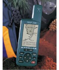
A Compact Full Featured GPS Receiver
A Compact Full Featured GPS Receiver
NOTES: "X" is a unit bundled with a City Streets map CD. See (HERE) for a review of Magellan's optional topographic map.
Despite the relatively low cost and conventional design, the M-330 in our opinion is a step forward in mapping GPS products. While Garmin has used "product differentiation" by equiping low-cost models with small but irritating feature deficiencies while NOT offering a "full featured model with large map memory", Magellan apparently decided to offer customers an attractive alternative.
Even though it does not offer "all features known", the M-330 offers all of the features we feel are essential for hiking and highway and marine navigation along with a large map memory and a robust and relatively watertight case at an attractive price. While the M-330 offers all of the important features of its similar cousin, the M-315, it has an improved user interface and the decided advantage of an 8 megabyte user uploadable map memory and a good quality base map. This unit now has "Pan and Zoom"!
Magellan offers a companion USA MapSend Streets mapping system for the M-330. The functions are similar to the familiar Garmin MapSource R&R product, except that the current streetname or approaching intersection is displayed (as with Garmin's more expensive MetroGuide maps). It offers map quality apparently of a later database than Garmin R&R maps but not as up to date as the newer Garmin MetroGuide USA (ver II). The original SOURCE of these Magellan maps is the US Tiger maps, but we see a number of corrections and new streets beyond the data in older Garmin's R&R and Lowrance map products. (See comparison map samples (HERE).
The MapSend (ver 1.00) that we evaluated was easy to use, and includes an important feature missing in Garmin's MapSource. To select a map area for upload, the user positions the cursor in the upper left of his desired area, holds the left mouse button, and then pulls the cursor to the point where he wants the other diagonal of a box to fall. MapSend generates a rectangle of this arbitrary user specified area. The user NAMES this map area and then can select one or more map areas for upload. Magellan's 330 (like other manufacturers) automatically erases map memory prior to uploading new maps. A new feature in Ver. 1.08 is that in addition to being able to find an address in the MapSend map, it now also can be done in the GPS itself and not just in the PC. The M330 can hold a maximum of FOUR separate and distinct user outlined map "areas" up to the 8meg max map memory. Map memory is NOT expandable beyond the 8 megs. (Some competitive models such as eMap can go to 128meg but larger memories can be expensive.)
Magellan has set a new price point for computer uploadable street maps by pricing the MapSend STREETS at US$50. (For the Fall of 2000, Magellan is offering STREETS and a data cable "free" with the purchase of a M-330 GPS unit. This price is about $270) Check latest prices (HERE). Note: The DataSend POI product designed for use with the M315/320 is NOT compatible with the M-330. On occasion, the uploaded street-level maps aren't visible, but re-booting the GPS generally displays the streets. The base map of the M-330 (Ver. 1.01) is generally superior to that of the earlier Garmin units up to and including eMap. It contains (some) local streets, more rivers and railroads, plus considerably more lake shoreline detail than that of the eMap.
For a review by GpsNuts see (HERE).
Also for a complete User Interface
.pdf diagram for Ver. 1.56 by Thomas Ferguson see (HERE).
MapSend CD
MapSend (like Garmin and Lowrance) does NOT offer real time tracking capability such as is offered by Delorme and others. Map assembly and loading (an automatic process) is rather time consuming compared with MetroGuide and an eMap. It takes about 15 minutes or so to convert plus about 10 minutes to upload an 8 meg map of the Atlanta area into M-330. (This using a P-II, 400mhz, 96meg computer.) This is the price of user flexibility and provides for the flexibility of being able to select large or small map sections of one's own choosing for upload. (Note: If you have room on your hard drive to do the "full install" of the 650meg MapSend program, Map conversion time is reduced by more than half.) Once a map conversion has occurred, MapSend stores the "converted" map section so that on future uploads, reprocessing the selected map section is not required. The initial handshake with the M-330 is at 4800 baud, but the system switches to higher speeds up to 115kbaud for map upload if your computer will accept this high speed. Many computers can operate reliably at 115kbaud with the M330 if the GPS has relatively fresh batteries.
Keyboard Controls
Pressing the MENU button brings up a common (and well organized) menu on all screens. The menu allows for Hide Nav Info, Map Setup, Track Clearing, Find Nearest database search, Route, Setup system, Sun/Moon, Fish/Hunt, Contrast, Alarms/Msg, and Help. The M-330 has unique "tips" screens which offer advice and information on using the GPS. We found this feature quite handy since our beta test unit came without a manual. The NAV and MAP screens are customizable with a selection from fourteen navigation data readouts. These include: bearing, heading, distance speed, VMG, CTS, ETA, ETE, XTE, TURN, Elevation, and Time. The Position screen can be alternated with the Lat/Long screen with the Left/Right rocker. Take heart! The M-330 can pan and ZOOM at the same time. One momentary push of the PWR button is all that's required to turn the power OFF 4 second time-out. Holding the button for several seconds turns on the display and keypad lighting.
Waypoints
If the Mark/GoTo button is pressed only once (and fairly quickly), the GOTO function is entered. The user can then select from user waypoints, nearby cities, highways, airports, waterways, national parks, etc. If Database > User (waypoints) is selected, either Nearest or Alphabetical lists are available. A new feature of Ver. 1.08 is that you now can view any selected waypoint at its map location.
NMEA
Compass and Sun/Moon Screens
Tracklogs
Software Compatibility
Ozi will exchange waypoint and track data with the M-330. However, with Ozi one can download Garmin waypoints and then upload them to the M-330 provided the waypoint icon number is less than 43 (the M-330 has a total of 42 icons). We doubt that any 3rd party software will fully support all functions without an update. Ozi, SA7/8, and Delorme TOPO can download and display tracks from the GPS. Ozi can upload them back to the GPS, but SA7/8 and TOPO cannot.
Version 1.08 Features
The firmware version No. of the unit reviewed is 1.08 (which is visible at power-up). HERE is how you can update the firmware in your unit.
Unit cost is about $$250US and $39US for the data/power cable. Accuracy is stated as 15m rms (95% confidence). Upon detecting no receiver movement, the receiver automatically goes into an averaging mode in order to refine its position estimate. A feature not seen in most other GPS receivers is, "The best time for hunting and fishing". (Folklore or Speculation, we could not tell which.)
What other GPS features
does the M-330 have?
Sensitive 12-parallel channel receiver
500 waypoints, 20 reversible routes with 30 legs
Waypoints recorded include altitude of the waypoint.
Proximity alarms with audio beeper
2-level Electro Luminescent Backlit display and keypad
Displays distance, bearing, heading, steering, speed, time to go,
elevation, XTE, time
Standard satellite elevation screen
1200 point Track record
BackTrack
Resetable trip odometer
"EZstart" position initialization
9 coordinate systems: Latitude/Longitude, UTM, OSGB, Swiss, Swedish,
Irish, Finnish, French and German
126 map datums
FRENCH and GERMAN
NMEA data output for PC interface
DGPS ready
It floats!
Pocket Size, 6.0" (h) x 2.0" (w) x 1.3" (d) / 15.75 cm x 5.0 cm
x 3.3 cm
Pinout: If you look at the back of the unit's contacts and number them from left to right as 1,2,3,4 then:
315/320/330 Contacts Other
connections
1 = Data in (pin 3 on DB-9) yellow
wire.
2 = Regulated 3.86vdc, red wire.
3 = Ground (pin 5 on DB-9) and
ground on cigarette-lighter plug, black wire.
4 = Data out (pin 2 on DB-9)
orange wire.
What is our overall opinion of the M-330?
The M-330 with its small size, light weight, sturdy construction,
watertight case, clear and detailed screen, excellent maps,
low cost and extensive feature set should be one of the most popular
GPSs of the year. There are no glaring feature omissions which
would cause users problems. The redesigned user interface is very
simple to use and learn. Battery life at 10 hours for just 2 AA cells
is acceptable. (Some users report somewhat less.)
For an approximate "street price" of $250 Magellan is currently offering
the M-330 with data cable and a "free" copy of MapSend STREETS (USA) for
a limited time. This is a superior value.
Check Latest PricesHERE.
What we did not like about the M-330.
1) The limited number of Datums available will be a problem for
some.
2) We like to see a "highway style cross track error display" for
marine use. However, M-330 does offer a XTE readout window.
3) We like to have an input for an external amplified antenna which
is not available on the M-330.
4) Uploadable maps are limited to the (good quality) USA highway
map. Hopefully Magellan will expand the available maps quickly.
5) Several users have complained about the long time necessary to
step through waypoints when the quantity gets large.
Note: version 1.05 firmware for the M-330 is available for download from the Magellan website if a M-330 purchased happens to have an earlier version of firmware.
There is a Magellan 330 user's forum HERE
Please send corrections and comments to
Joe Mehaffey (features write-up)
or
Jack Yeazel (software and
mapping)