NOTE: MapSend Topo also upgrades the Map 330 to Ver. 2.03. This $86US program, check prices (HERE), adds many features to the GPS to take advantage of the topographic data loaded from the CD. For example, if the topographic data is loaded, you can view the vertical profile of any road or highway in the database. In addition, you can get updates of the terrain profile in the direction you are moving, a useful feature for the hiker or pilot. One can also find a database object by name, and select from 8 languages on the initial bootup.
Background:
The source of Magellan topo maps are USGS 1 dg DEM (Digital Elevation
Model) data. Here altitudes are recorded at the vertices of the 3 sec x
3 sec (grid) that covers all CONUS. This is about 90m x 90m cells.
A similar linear resolution grid covers Alaska. Magellan has developed
proprietary compression algorithms that allowed it to convert 2.758 Gbytes
of original US DEM data into 72.7 Mbytes. Magellan has compressed
data that can be uncompressed on the fly in a unit. Alaska adds another
29.4Mbytes compressed out of the original 1.238 Gbytes Alaska DEM data.
Magellan reports that the compression is done with no more than 3 m RMS
error and with no more than 10 m max error of compression.
MapSend Topo simplifies route planning and navigation during outdoor activities with features that help users determine the terrain along routes, or find alternate routes when the terrain is too steep or impassable. Users can access a graph profiling the vertical line of elevation along routes, roads, trails or other linear map features. In addition, users can search the database using names, addresses or coordinates to pinpoint streets, campgrounds, trails, rivers, lakes and 50 other categories of topographic points of interest from parks and oil fields to summits and caves.
Another change is the ability to find an item quickly in the database
with a "keyboard" search page. However, this method can be used with
Points of Interest but not with User waypoints which require scrolling
the total list. MapSend Topo software ships with a Quick Reference
Guide. Compatible Magellan MAP 330, MAP 330M and MAP 330X
products are sold separately.
Click (HERE) to get a list of the updated features provided by Ver. 2.03/2.04.
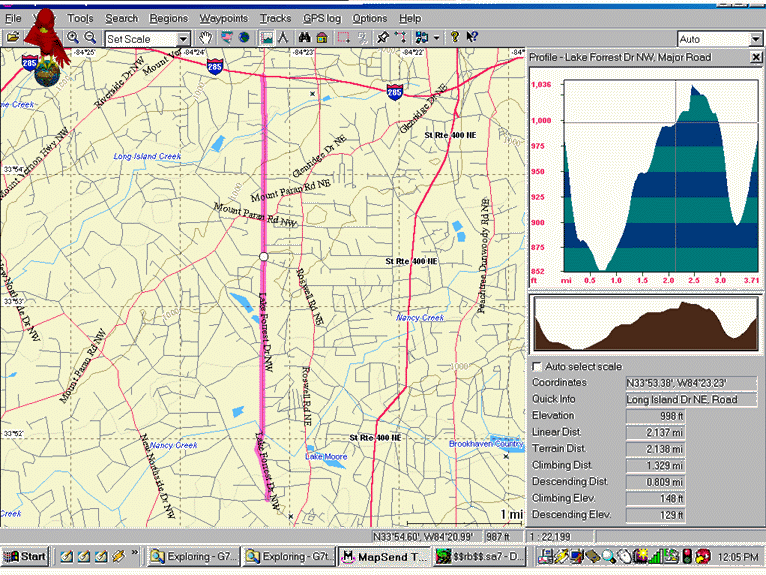
MapSend Profiles:
In the above graphic, a street has been selected for a profile.
The profile (right) runs south to north. The lowest part crosses
'Nancy Creek' (visible on the map). "Quick Info" shows the cursor
(also a circle on the map) is placed at the intersection of Long Island
Dr. NE, and "Elevation" shows 998 feet, which is the same as that scaled
off a USGS topo map. The second dip is at Long Island Creek (also
shown on the map). These profiles are also shown on the GPS, but
we don't have a "screen shot" program to capture them.
Terrain Profiles on the 330Map GPS:
As part of setting up the Map Page, one can select Customize and
then select Terrain Project or Horizontal Profile. In Terrain Project,
the unit is automatically set to track-up. Then one sees the profile
of the terrain in the direction of travel out to the zoom level of the
screen at the bottom. Horizontal Profile shows the terrain to the
left and right of travel. In the track-up mode, the screen update
is slower, but adequate for walking.
In the Terrain-Project view, there is an icon of "present position" to the left of the profile along with (GPS) present-position altitude. This icon is superimposed on the calculated profile, and is generally close to it. In the Horizontal-Profile view, the present-position icon is in the middle of the screen. All vertical scales are adjusted automatically. One can also review the track-history profile (with GPS data) or the profile of a Route (with terrain data). The GPS profile can have either more or less detail than the terrain data.
Cursor Elevation Readout:
A unique feature of the Magellan topo maps, not found in the Garmin
maps, is the ability of the M-330 topo cursor to read out the elevation
of the panned marker. Checking the cursor for accuracy against the
latest USGS 7 1/2' topo map elevation readings at published intersection
elevations showed that the accuracy is pretty good:
Intersection USGS topo
Magellan topo cursor
1
318m
312m
2
311
310
3
256
260
4
336
333
5
312
310
Comparison of Magellan and Garmin topographic
maps in the Atlanta area:
Compared to the Garmin USA Topo map (bottom), the resolution and
detail of the Magellan contour lines (below) are rounded off. This
is understandable, to some extent, since the Magellan Topo maps come on
only one CD as compared to Garmin's three. However, the Magellan
street-map data are much later than the Garmin topo street-map data which
is 20 to 30 years old. One might say the "Magellan map is a good
street and profile map with a secondary contour-line feature, while the
Garmin map is a good topo map with a secondary street feature."
These two types of map derive from entirely different technologies. The below maps are compared to Garmin's USA Topo which derive from the USGS DLG (Digital Line Graphic) 1:100,000 vector maps.
Garmin USA Topo Map (10m Contour Intervals)
For a comparison of Magellan Topo contours with USAPhoto map contours, see (HERE).
Installation:
Loading the Magellan topo map program onto a computer is more complex
than the Garmin method. First one must install a new base-map file.
There are two in the "MapSend Topo US" directory under the Start Menu on
the Windows desktop. "North America Magup" for the Map 330 and "Marine
North America Magup" for the Map 330M marine units. After the basemap
is installed, then the topo map program can be installed. The highest
upload baud-rate is 19,200. Uploading maps to the GPS was standard
procedure.
These files can also be also be found in:
C:\Program Files\Magellan\MapSend Topo US\MAGUP\na\north america\
magup.exe and
C:\Program Files\Magellan\MapSend Topo US\MAGUP\marine na\marine
north america magup.exe,