The Plotting Page can have one of Four
Screens
 .
. .
. .
.
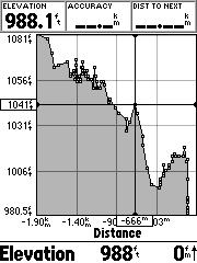
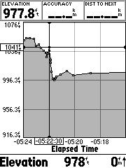
Elevation vs Distance - Elevation
vs Time - Local Barometer vs Time - Ambient Pressure
vs Time
General:
The GPSmap 76S (ver. 2.00) is about $375US
(check prices HERE).
For a review of the GPSmap 76 see (HERE).
The 76S is physically the same as the GPSmap
76, has the same screen resolution
(but has 24MB of map memory instead of 8MB for the 76). Also the
tracklog has been increased to 10,000 trackpoints, and the case colors
are reversed.
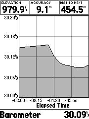
Electronic Barometer:
This barometer is considerably different
from the Vista barometer. In the Vista, the Barometer pressure readout
will change inversely as you travel up and down. (The barometer reading
should not change when moving up or down except as atmospheric pressure
changes).
The 76S can compute the correct Barometer pressure even if you are changing altitude. When allowed at least one hour for the GPS to calibrate the barometer (see the third plot screen below for gradual calibration of the pressure from a cold start), the barometer readout was within 0.02" (about 20 feet) of the weather bureau measurement. It will also take this long for the barometer altitude to indicate the best accuracy, see plot (HERE). GPS altitude settles down after about ten minutes.
Barometric altitude is displayed on all screens except the Satellite Page where only the GPS altitude is displayed.
The elevation accuracy of the calibrated barometric altitude under dynamic conditions appears to be more sensitive to altitude changes than the normal GPS altitude display on other makes and models. The barometer can detect altitude changes as little as 5 feet.
Static altitude accuracy tests (after calibrating the altimeter over a known elevation) averaged better than three feet when checked over several test points spread out over about two miles. For a short period of time accurate Barometer altitudes can be obtained with the GPS turned OFF -as in the cases where the test sites are obscured by tree cover.
GPS altitude can be read on the GPS Satellite Page. So YES(!), you can read your altitude in an airplane. And as with the Vista, if the GPS altitude is more than 1,000 feet different from the barometer altitude, the barometer is not calibrated by the GPS and will continue to read "cabin altitude". GPS altitude is only displayed on the Vista starting with Ver. 2.25, but this altitude isn't updated continuously as in the 76S.
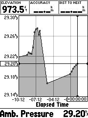
Ambient Pressure:
This is the pressure you would read from
a mercury barometer. As you increase altitude the ambient pressure
goes down and vice versa. Thus the plot of ambient pressure will
follow inversely your altitude changes. The ambient pressure is calibrated
when you do a manual calibration or use the Auto Cal, GPS calibration.
Calculating the Barometric
Pressure in the Auto Calibrate Mode:
The 76S has two setting to do this: Fixed
Elevation mode and Variable Elevation mode. Fixed Elevation mode
uses the calibrated altitude as truth and assumes all changes in the pressure
sensor are associated with the barometric pressure. Variable Elevation
mode uses GPS altitude in computing what the barometric pressure is.
The fixed mode will be more accurate if you accurately know your elevation
& are stationary. The variable mode will work reasonably well
in all other cases.
When using GPS to calibrate the barometer, the function no longer assumes you will stay at a static elevation. When manually calibrating the altimeter, you can choose if you wish to remain at a static elevation (as in using for a weather station mode) or if you intend to move.
The Plotting Page can have one of Four
Screens
...
Elevation vs Distance - Elevation
vs Time - Local Barometer vs Time - Ambient Pressure
vs Time
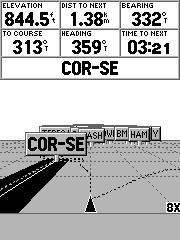
Plot-Page Analysis:
Moving the rocker left will display "cross
hairs" over the plot and read out your recorded data versus time or distance
(see above). Elevation is stored in the track log, so each time a
track point is stored so is the elevation. Consideration is given
in order to provide good representation of altitude changes, even if the
normal horizontal criteria for storing track log points is not met.
Barometric readings are stored every 15 minutes. Provided the "cross
hairs" are not activated, the plots will update themselves automatically.
Barometer plots can be recorded for up to 48 hours.
The Plot Page is a new page to the 76's 5 pages, for a total of 6 pages. These pages cannot be selected individually, as in some makes, and one must scroll through them to get to the page of interest.
Marking a Waypoint:
If you record a waypoint, it includes
the Barometric Altitude. However, if you AVERAGE the waypoint, the
altitude immediately changes to the GPS altitude, and THAT altitude is
averaged.
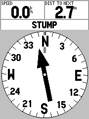
Electronic Compass:
This appears to be the same compass as
in the Vista, except it has a larger display, and is calibrated with the
unit in the horizontal position. It is activated when the unit is
traveling slower than some selectable speed. When calibrated on a
non-metallic flat surface in a magnetically undisturbed area, the 76S heading
accuracy was within the spec limit of 2°. Although no warning
is displayed when batteries are replaced ( as with the Vista) the unit
should be re-calibrated in order to retain its 2° accuracy. In
a magnetic-free area, the 76S compass averaged 1.25° error.
By holding down the Page key, one can quickly turn the compass ON and OFF as needed.
Compass Page with Relative-Bearing Pointer
* 3-D Navigation Page
 ............
Area Calculation:
The GPSmap 76 has an area calculating
feature, but you have to hunt for it. To use it, you
clear the tracklog and go hike around an area. Then go to Tracks
in the main menu and save the Entire tracklog. When you do this,
you will be shown a screen which has the area bounded by the track.
You can also select one of the saved tracks and find the area as well.
This is also where you find the Trackback feature.
Geocache:
An unavoidable consequence of the 76 and
76S having a vertically oriented helix antenna, make the 76S less accurate
when observing the compass and the relative bearing pointer to the geocache/waypoint.
The position errors of the 76S increase from two to three times the errors
when used in the vertical position. For a comparison see (HERE).
The Vista, with its horizontally oriented patch antenna, is more useful
for hunting geocaches, since the compass is usable in this position.
However, the 76(S) units work well in an automobile or boat where you can
read the unit in the vertical position with best accuracy.
Editing
NMEA:
Unless you press MENU when the NMEA Interface
is highlighted, select "Setup NMEA Output", and mark the "GPS Status (GSA,
GSV)" box, the satellites don't appear on SA Watch (or any other program).
Other users may need the "Waypoints/Route (WPL, RTE)" box also checked.
Elevations, including NMEA $PGRMZ, downloaded tracklogs, and recorded waypoints contain the barometer altitude (provided the waypoints are not averaged, in which case they are GPS altitude.) The "GPS Elevation" field on the Satellite Page and NMEA sentence $GPGGA are based on the GPS altitude. Real-time tracks recorded by MapSource will contain the GPS altitude, if one uses the Garmin mode. In the NMEA mode, no altitude is recorded.
Battery Life:
We have measured the current drain at
175ma (an alkaline life of about 10 hours) and with the compass off, 125ma
(about 14 hours life). A rundown test with 1600mah NiMH batteries
lasted 7hrs 40min and 8hrs 55min with the compass off. To compare
this with other makes and models see (HERE).
Trip Computer:
The Max Speed recorded while standing
still was 147mph. (Not much use in court!)
Possible Loss of correct Date in the
76 -may apply to the 76S:
If an incorrect date is
displayed, performing the master reset described below will correct the
problem. Note: The incorrect date displayed on these units does not affect
navigation. This problem may recur if the GPS 76 or GPSmap 76 is stored
without batteries. Recurrence can be prevented with an update to
the latest software. Software updates are available for free download for
the GPS 76 and the GPSmap 76.
Master Reset -from Garmin's Site:
Warning: The Master Reset
sequence will delete all routes, user waypoints, and tracks from memory.
View the software version
by completing the following steps:
1. Press the Menu key twice to access the Main Menu.
2. Select System Info, and press enter.
3. The software version will be displayed on screen.
For Software Versions of
the GPS(map) 76, 2.05 and above :
1. With power off, press and hold QUIT, MENU, and ROCKER DOWN.
2. Press and release POWER.
3. Release ROCKER DOWN.
4. Release QUIT and MENU after 5-10 seconds when the welcome page is displayed.
5. Memory is now clear.
6. Place the unit outside with a clear view of the sky until satellites
are acquired. (The unit will display "3D GPS Location.")
For All Software Versions:
Confirm that the Year is
displayed correctly on the Satellite Status page after satellite acquisition.
The Date and time displayed are for the United States Central Time Zone
and usually will not match local time until the Time Zone is configured
in Setup.