03-14-02
draft draft draftRecreational Grade GPS - Digital Mapping Software and PDAs - Potential Uses For Incident Management Teams
Introduction
The growing use of reasonably accurate, "feature-rich" recreational-grade Global Positioning Systems (GPS), handheld computers e.g. Palm, Visor, iPac, Casio, Jornada, Sony, personal digital assistants, ( PDAs), and easy-to-use digital mapping software have created new mapping and documentation applications for use in Incident Management.
Disclaimer
The products described below do not represent product endorsements. There may be products that were not included in this survey that I simply didn’t know about. The author did not personally test some of the products described. The use of recreational-grade GPS cannot be a substitute for applications that require a registered professional surveyor with cadastral survey equipment. The relative accuracy of recreational-grade GPS may or may not meet the needs or standards for a corporate GIS.
Recreational - Grade GPS
Magellan introduced the first recreational-grade GPS in 1989. It cost $3000, wasn’t very accurate, and had very few features. Today, units range in cost from about $100. to $500. and are both reasonably accurate and often "feature-rich". Industry sources predict current sales of recreational-grade GPS of $8 billion annually to double in the next three years. Part of the reason for the rise in popularity of recreational-grade GPS has been changes in military-imposed Selective Availability (SA). Prior to May 1, 2000, typical 30-meter accuracy had restricted the use of recreational-grade GPS primarily to hikers, hunters and fisherman who did not demand high accuracy but wanted a low-cost alternative to survey-grade GPS. In May, 2001, SA was removed and GPS accuracy was greatly improved (from 50-100 meters previously to10-20 meters now). Better accuracy can be attained with the addition of a DGPS beacon receiver (2-6 meters), and, with new Wide Area Augmentation System (WAAS)-enabled GPS, three-meter (or better) accuracy is possible. Even greater accuracies (to 10cm) are possible with specially designed software that can differentially correct recreational-grade GPS (GPS Post Pro and GRINGO software).
Feature-richness In Recreational-Grade GPS
In addition to improved accuracy from features like WAAS, the current generation of recreational-grade GPS have many other useful features such as, moving map screens, routable maps, track profile display, electronic compass, barometric altimeter, calendar, almanac data, and other features often absent in survey-grade GPS units. These units are relatively inexpensive (10-20 per cent the average cost of the cheapest survey-grade equipment). Best of all, recreational-grade GPS units are relatively easy to learn how-to-use.
One feature missing in recreational-grade units has been interface capabilities with data logging equipment (a highly desirable feature found in most survey-grade GPS). Due to inherent differences in signal reception and processing, most recreational-grade GPS data could not be differentially corrected. Finally, there have been problems downloading data from recreational-grade GPS into corporate Geographical Information Systems (GIS) such as ArcView. A number of third party freeware and software products have been developed to address these problems. Nearly all PDAs now interface with GPS and can directly or indirectly integrate spatial data with other applications. With the addition of flash memory, PDAs can handle vast amount of information (up to 1GB Compact Flash cards are available). To deal with problems downloading information into corporate GIS, there are now software programs that greatly ease this problem (DNRGarmin , AV_Garmin (both ArcView extensions), Garmin MapSource, OziExplorer and Waypoint+).
PDAs
Coincident with the development and improvements in recreational-grade GPS have come efforts to better integrate GPS with handheld computers or PDAs. PDAs will accept a variety of GPS equipment. Several companies offer special GPS units to "sleeve" directly into PDA ports. Software is now available to download digital topographic maps into Palm OS and Pocket PC devices. Linked to GPS, the PDA screen becomes a moving map that automatically scrolls as the user changes location and allows users to input waypoint, tracklog and routing information. PDAs can also be equipped or integrated to work with a variety of other devices including printers, digital cameras, e.g. http://www.geospatialexperts.com/gpsphotolink.html
, cell phones, optical scanners and sensors. With wireless service, data can be logged into the PDA and then E-mailed to provide near "real-time" mapping and other incident information.
Digital Topographic Software for PDAs – Examples
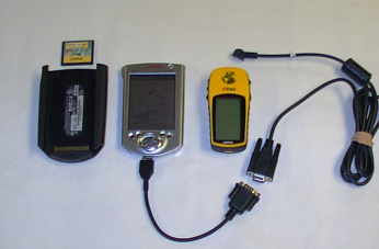
Several manufacturers of digital mapping software offer products to work in either PalmOS and/or PocketPC formats. Without "sleeved" GPS hardware, equipment is linked with appropriate cables between recreational-grade GPS units and the PDA. Most cables cost from $20 to $35. Figure 1 shows a typical configuration including flash memory for the PDA.
Figure 1- left to right (PocketPC case with compact flash memory card, Pocket PC with cable to serial, Garmin ETrex GPS receiver with download cable)
MapTech Pocket Navigator
MapTech’s Pocket Navigator works with MapTech Terrrain Navigator series digital mapping in PocketPCs. Pocket Navigator includes no data and only works with MapTech Terrain Navigator software. Hardware requirements include a minimum 4MB of free memory. Software features include creation and editing of waypoint, tracklog and routes. Routes can be "drawn" on-screen and then uploaded into GPS units. It has a "find place" feature and GPS functionality. It has an easy-to-use zoom feature and can provide a high-resolution color image on the PDA (see figure 2 and 2a). MapTech Terrain Navigator topographic mapping software is available for the entire United States. This software costs about $129. for the multi-state series (e.g. Arkansas, Oklahoma and Northeast Texas). MapTech Pocket Navigator costs about $95.
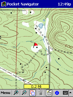
Figure 2 – - MapTech’s Pocket Navigator Screenshot (Russellville West Quad – Arkansas- Maptech Terrain Navigator Software)
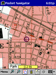
Figure 2a – Downtown Russellville, AR with attached Garmin GPS V inputting location (circle with crosshairs)
TOPO! Sync USA
TOPO! Syne USA Software works only with National Geographic’s TOPO! Digital mapping software in both PalmOS and Pocket PC devices (Figure 3 and 3a). Map coverage covers 31 states currently. TOPO! Digital maps cost about $89. per state. A separate piece of software TOPO!GPS ($35) is needed for GPS functionality for use with older TOPO! mapping. Newer products include GPS functionality. Topo Sync USA is used to download the Personal Computer (PC) mapping from Terrain Navigator into a PDA . It cost around $35. TOPO! Works with both PalmOS and PocketPC equipment. It’s features include a "draw" tool to generate an on-screen polygon (Fig.3a). Mapping includes the option of using shaded relief images (Fig. 3).
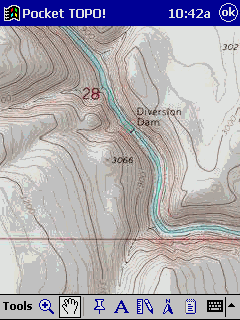
Figure 3 - TOPO! Sync USA screenshot – shaded relief
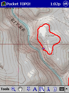
Figure 3b – TOPO! Sync USA screenshots of TOPO! mapping on a Cassiopeia E-125 (Baker City, Oregon – Powder River) and freehand drawn polygon (using stylus on PocketPC screen)
DeLorme Solus Pro 3.0
Solus Pro 3.0 works in PalmOS formats (Figure 4). Mapping can be downloaded from any of DeLorme’s mapping software products including Street Altlas, TopoUSA and 3-D TopoQuads. The software requires a 8MB memory PDA. It features on-screen waypoint creation, distance measurement tool, a routing (directions) tool and GPS functions. It has a zoom feature but doesn’t provide as much on-screen flexibility as some other products. DeLorme’s map products are available for all the U.S. Solus Pro 3.0 costs $50. DeLorme’s PC products vary in cost. TopoUSA cost about $95. but provides coverage of the entire U.S. as a Digital Elevation Model (DEM) product. 3-D TopoQuads are about $89. per state.
Figure 4 - DeLorme Solus Pro 3.0 Advertisment
OziExplorerCE
OziExplorer is a unique and versatile product that will allow users to calibrate any map image for use in a PocketPC. The software is designed to work with scanned or "packaged" digital 3rd party mapping. It comes with a few demo maps. Data can be procured through a variety of sources such as those found at http://www.cast.uark.edu/cast/geostor/data_available/resources/index.htm or http://geode.usgs.gov/
OziExplorer software has a full suite of waypoint, route and track tools along with full GPS functionality. It has a decided advantage over some other products in that it can use .bmp, .tiff, and DRGs, with ease. On the PC version, it has a file menu option to convert tracks and waypoints to ArcView shapefiles. Screen images are full-color with excellent resolution. OziExplorerCE costs about $25. OziExplorer Pro version for the PC costs $75.
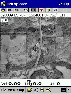
Figure 5 - OziEplorerCE Screenshot Dover DOQ (Arkansas)
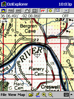
Figure 6 – Screenshot Administrative Map Sylamore Ranger District Ozark-St. Francis National Forest
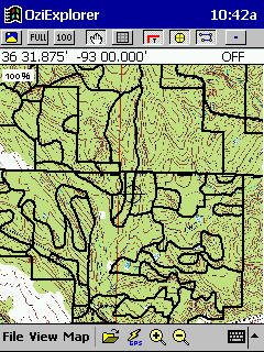
Figure 7 – OziExploreCE screenshot (downloaded –exported view of Bayou Ranger District stand boundary data with DRG background from ArcView).
Fugawi
Fugawi 3.0 works in PalmOS devices. Like OziExplorer, Fugawi can take virtually any map image and convert it for use in a PDA (Figure 8). It features include a full set of waypoint, tracklog and routing tools with full GPS functionality. It lacks zoom features. Screen resolution is good. It cost about $30.
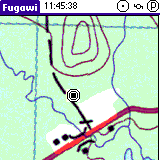
Figure 8 -Fugawi 3.0 Screenshot Advertisement
ArcPad
ESRIs ArcPAd is designed for the "high-end" GIS user (Figures 9). It is relatively expensive ($495.) but has powerful features. It requires a PDA with a minimum 64MB memory.
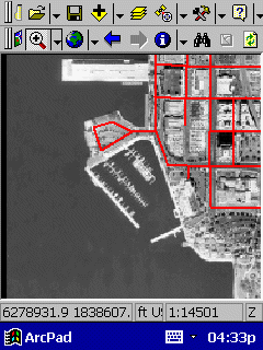
Figure 9 – ArcPad PocketPC Review Advertisement
MapXmobile
MapInfo’s PocketPCs application is still in development (Figure 10), but should soon be available. Like ESRI’s mapping application, is appears to be for the high-end user. No cost information is available at this time. More information is available at the website http://www.mapxmobile.com.
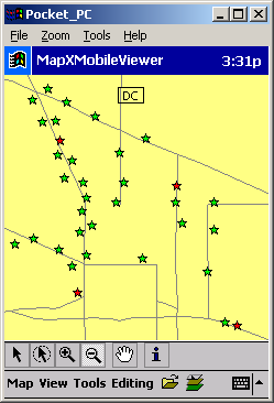
Figure 10 – MapXMobile screenshot website advertisement
GPSEasyCE
At $30., GPSEasyCE may be the least expensive stand-alone software package for PocketPC environments. Although this software wasn’t tested the product advertisement indicates that the software has a range of features and can covert any .bmp (bitmap) image into a moving map able to scroll with NMEA GPS inputs.
Figure 11 – GPSEasyCE screenshot from advertisement
Teletype
Teletype sells sleeved GPS and software bundles or software bundles for use with PocketPCs and GPS. The software bundle costs $95. and the Garmin converter software costs $69. The software product works with TerraServer (see http://terraserver.msn.com/default.asp
And http://www.teletype.com/. Although this product was not tested, there appears to be a lot of features available with software and a number of favorable product reviews. [Ed. note: this product is now free]
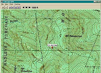
Figure 12 – Teletype Mapping software with TerraServer DRG download (product advertisement)
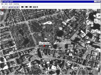
Figure 13 – Teletype Mapping software with TerraServer Aerial Photograph download (product advertisement)
Realtime DGPS and Differentially Correcting Recreational-Grade GPS Data
There are ways to improve recreational-grade GPS accuracy. One involves the use of position-averaging. Another method is the use of real-time DGPS via a receiver attached to the GPS device. Another means for better accuracy is to use post-processing software (DeLorme’s Post-Pro – cost $99. http://www.delorme.com/gpspostpro/review.asp with DeLorme’s Earthmate and Tripmate GPS receivers (made by Rockwell) to differentially correct data. For Garmin GPS, GRINGO software from England (University of Knottingham – cost 65 UK pounds) can be used to yield differentially corrected data for waypoints. Depending on equipment and methods employed, average accuracy ranging from five to ten meters is typical with two to six-meter accuracy common with either real-time DGPS or WAAS reception. With available software to differentially correct recreational-grade GPS, one-meter or better accuracies are possible (to 10 cm with Gringo software).
Mapping Resolution
The question of GPS accuracy may be moot depending upon the intended use of the information and/or mapping standard. When actually mapped, recreational-grade GPS waypoints and tracklogs may appear visually on a map in the same locations as those derived from more accurate data collected using survey-grade equipment. For example, in typical applications, a pencil-lead width on a USGS 7 1/2 minute topographic map is a 60-foot corridor on the ground. Similarly, a small dot is actually a circle 50 feet in diameter. Hence, at the commonly used scale of 1:24000, there may be no discernible difference in a map location marked using a recreational-grade GPS unit versus the most expensive cadastral-survey grade GPS equipment. This argument may be oversimplified, but the fact remains that much of what initially goes into a corporate GIS database is no more accurate, and indeed often less accurate, than twenty meters.
Getting Garmin Into ArcView
Some of the problems in using Garmin GPS equipment in Incident Management have been interfacing with corporate GIS, particularly ArcView and resolving concerns of database managers in regard to the quality of data (e.g., correct datums, projections, accuracy). One way to address some of these concerns may be found in the use of a relatively new ArcView Extension available through the Minnesota Division of Natural Resources (DNRGarmin) <http://www.dnr.state.mn.us/mis/gis/tools/arcview/Training/WebHelp/Training.htm>. This extension allows users to enter Garmin inputs directly into a reprojected map view. There are other methods to process Garmin waypoint and tracklog data. Using Garmin MapSource version 4.06 or newer, choose the export to .txt option; create an Excel spreadsheet to facilitate migrating the text-delimited file into ArcView. The imported data may still need to be re-projected using the ArcView extension projection wizard. Another method involves the use of WayPoint + (the Professional version works best). After downloading GPS information into WayPoint +, use the ArcView extension AV_Garmin to complete download process. Data may still need to be re-projected. Yet another way to get Garmin data into ArcView is to download it first into Oziexplorer Professional. This software has a menu choice of exporting into ERSI. Reprojection may still be needed.
Examples of Applications
Because the technology is relatively new, there are few published examples for specific use of handheld computers (PDAs), GPS, and mapping applications in Incident Management. The following link does provide one useful example (Viejas Fire Mapping) http://spatialnews.geocomm.com/features/viejasfire/.
Another example of the use of OziExplorer mapping software in wildand fire and other resource management can be found at www.fs.fed.us/r1/fire2001/tools/Ozi%20Explorer%20Forestry%20and%20Fire%20GPS%20Applications%20.doc
There is an OziExplorer user group on the internet http://groups.yahoo.com/group/OziUsers-L/, that provides a variety of information for users.
The potential uses of these technologies in Incident Management seem endless. Fire behavior programs are available for use in PDAs ( FireAway 2.01 (All You Can Web, Inc.)). The ability of bringing vast amounts of high quality mapping of all kinds (DRGs, DOQs, ArcView, etc.) to the fireline literally "in your pocket" and link this information to GPS is an important development. Using the PDA as a communications device both on and off the fireline has significant implications for all types of Team applications including Planning, Operations, Safety, Information, Logisitics and Finance.
In the Planning and Operations functional areas, mapping data could be logged on both GPS and PDAs. This information could then be downloaded in near "real-time", or at the end of shift to provide accurate maps for Incident briefings and Incident Action Plans. Special fuels/vegetation mapping from corporate GIS databases could be downloaded into PDAs for field use. Linked to digital cameras, information on fire behavior, smoke and control efforts could be better documented. Unique hazards could identified and safety messages could be updated to include specific mapping, photos, weather changes or other key safety information. Digital mapping and photos could be posted on websites for the public and other agencies. Other digital imagery including both normal color and Infrared "cam" movies could be recorded. Logistical support could be facilitated by having DOQ information and other GIS transportation mapping information available at both the ICP and fireline.
Summary
The potential use of recreational-grade GPS units, simple-to-use mapping software and PDAs in Incident Management links new technologies to mapping needs often encountered in emergency situations. With these tools, reasonably accurate geospatial information can quickly be reckoned, mapped and used for strategic and tactical purposes.
References and useful links
http://www.gpsinformation.org/dale/Palm/soluspro.htm
http://www.gisvisionmag.com/software_reviews/gps.pdf
http://fsweb.sdtdc.wo.fs.fed.us/programs/fm/fy01/gps/gps_cover.html
http://spatialnews.geocomm.com/features/viejasfire/
http://www.microsoft.com/mobile/pocketpc/reviews/arcpad.asp
http://gisstore.esri.com/acb/showdetl.cfm?&DID=6&Product_ID=1601&CATID=112
http://www.nottingham.ac.uk/iessg/gringo/
http://www.solar.sk/gpseasy.html
http://www.dnr.state.mn.us/mis/gis/tools/arcview/Training/WebHelp/Training.htm
This word document was converted to html by Dale DePriest and a few link corrections were made but is otherwise exactly as Fryar wrote it.