Receiver WAAS On
and Off, 30-Minute Tests in the Open, Night and Day
(Red
indicates WAAS On)
Summary:
WAAS °95% ERROR ° DRIFT/min ° AVG.ERROR* ° END TIME °
RUN TIME ° AVG.ALT.ERROR*#
(Day Tests)
Vista 2.15
on 5.8m
3m 3.4m@282°
11:21am 30 min. -2m
Vista 2.15 off
7.6m 3m
5.1m@309° 11:59am 30
min. -2m
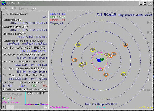
Magellan M-330
n/a 8.4m 0m**
7.0m@001° 12:30pm 30
min. -1m
Magellan 330 WAAS on
2.5m 1m**
2.0m@273° 10:36am 30
min. 0m
(Night Tests)
Vista 2.15
on 2.1m
3m 0.9m@306°
10:33pm 30 min. -6m
Vista 2.15 off
1.8m 2m
0.7m@352° 11:08pm 30
min. -8m
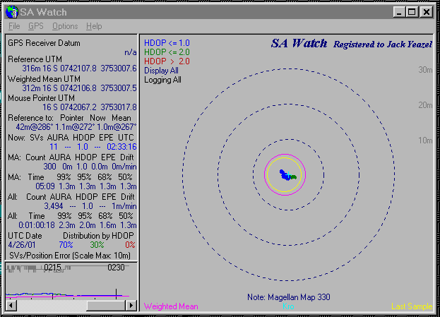
G-76 Map 2.04
on 1.8m
2m
0.8m@292° 7:05pm
30 min 0m
G-76 Map 2.04 off
1.9m 2m
0.7m@292° 6:24pm
30 min +1m
Magellan M-330 n/a
2.0m 1m**
1.0m@267° 10:33pm
1 hr. -2m
*Error after averaging in 2-D
#Based on a newly surveyed altitude of 314m
** Due to automatic averaging
Observations:
GPS accuracy is generally better at night
when the ionospheric errors are less.
WAAS ionospheric corrections are therefore
less apparent at night.
The reference-point accuracy is confirmed
with the average night error of 0.8m.
This (and other) tests indicates non-corrected
GPS units have a northward error bias.
NOTE:
The WAAS (WGS-84 datum) receivers have a nighttime north-westward bias
of about
1m as compared to the
reference point which was established with DGPS (NAD-83 datum).
In the Atlanta area,
WGS-84 coordinates are 0.86m@329° from NAD-83 coordinates.
Those that would like
to measure this offset at their loaction can run HTDP.EXE
or
the interactive version
(HERE).
Survey:
USInfrastructure, Inc. later confirmed that the original DGPS averaging
in the NAD-83 datum was accurate to within 0.05" of Lat/Long.
Day Tests
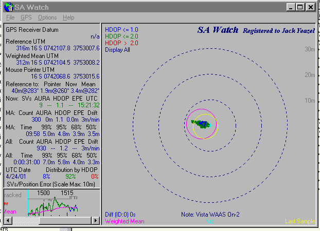
Vista WAAS ON, 95% Errors=5.8m
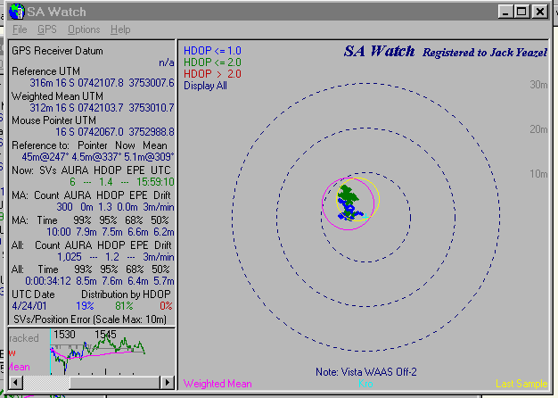
Vista WAAS OFF, 95% Errors=7.6m
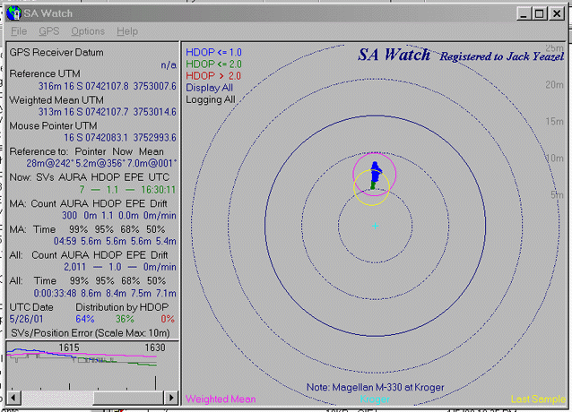
Magellan M-330, 95% Errors=8.40m
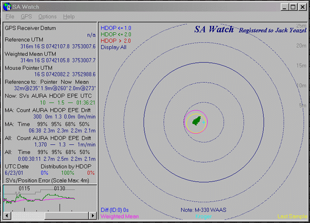
Magellan M-330 with WAAS, 95%=2.5m
Night/Evening Tests
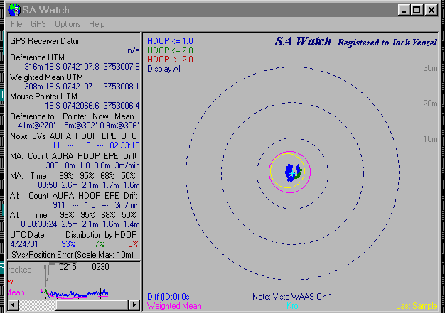
Vista WAAS ON, 95% Errors=2.1m
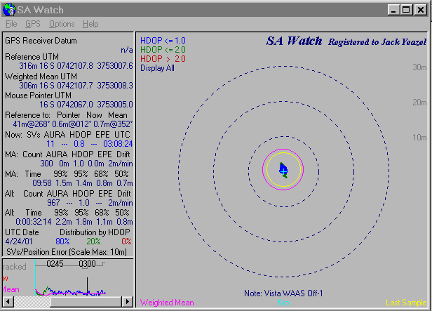
Vista WAAS OFF, 95% Errors =1.8m

G-76 Map WAAS On, 95%=1.8m
G-76 Map WAAS Off, 95%=1.9m
Magellan M-330, 95% Errors=2.0m