It only takes about an hour to get valid GPS accuracy data with SA turned off. It's important to test in the clear away from tree to get the best results. It's been noticed that GPS is most accurate at night and least accurate in the afternoon. With SA Watch, you can check this out. With several sessions of averaging, the SA Watch Weighted Mean should provide you with a Reference Point position to within one meter.
SA Watch Operating Screen
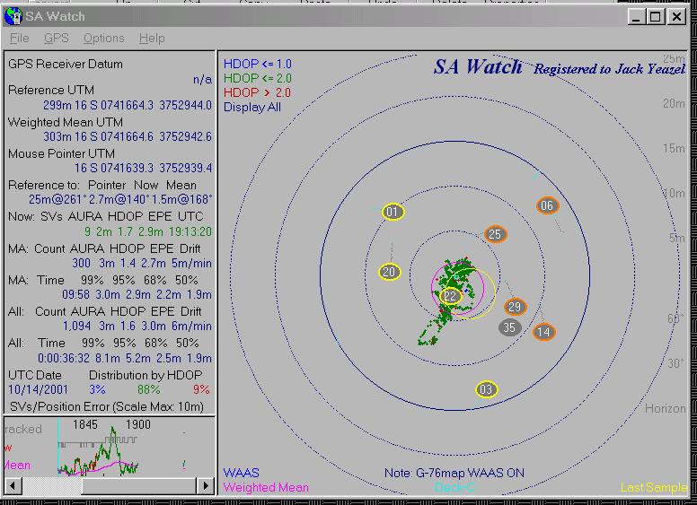
The reference point 'Reference UTM' (and the blue '+') coordinates come from the a first-order survey marker. The weighted mean of the Vista was 1.2m@207° from this reference point. "WAAS" indicates that the receiver is receiving WAAS differential signals. If a DGPS receiver is used, the "ID" will indicate which ground station is being received.
SA Watch is now fully compatible with Garmin's new NMEA 0183 Ver 2.3, and if selected, the plot will show the current satellite positions (yellow ones rising and orange ones descending). A plot of the satellite trails can also be shown, if selected.
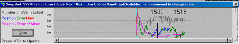
The first item in Weighted Mean is altitude weighted by VDOP (if weighting is selected) during a live recording. When importing a .dat file, the Plot Screen will show altitude weighted by HDOP. The Statistics Page (F5) will show the simple mean. In the plot, the Vista altitude mean was within 1m of the reference altitude.
Setting Up SA Watch
Operating SA Watch
PLOT: The center of the magenta circle is the Weighted Mean as compared to the current reference point, and its radius is the average EPE. (The line graph at the bottom shows a running account of this difference.) The center of the yellow circle is Present Position, and its radius is current EPE. The plot of blue/green/red dots are a 'cookie trail' of present positions as compared to the reference point, color coded for HDOP (also shown in the line graph).
LINE GRAPH: In addition to a plot of current position error, weighted mean error, and the number of sats tracked, it shows UTC time (every 15 minutes). (The graph can be scrolled left and right) .
TABLE (at left):
Now:
AURA = Average User Range Accuracy; HDOP = Horizontal Dilution of Position;
EPE (Garmin only)
MA
= Moving average (per point count set in Options)
All:
Count = Total points collected
HDOP = Average HDOP
Drift = Average movement speed due to SA and errors
Time = Total time of usable points recorded
xx% = Percent of data points not exceeding the error shown.
NOTE: The 95% number is important, because it can be compared to
the Selective Availability specification of 100m maximum expected error,
95% of the time.
GPS HORIZION: GPS > Show GPS Horizon (or Ctrl-H) will plot the limits of the satellites' tracks in the sky, and can be used to see what obstructions you have at your local viewing station. Then pressing "OK" will bring you back to the track-plot page. See an example (HERE). It takes about 12 hours to draw a complete outline of the GPS horizion.
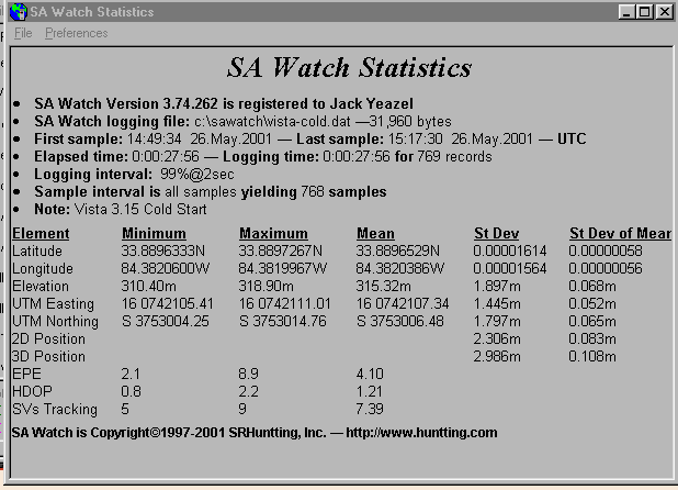
STATISTICS: Press F5 for the Statistics Page which will give
you the Mean Altitude plus other data, such as Standard Deviations
and Standard Deviation of Means. To see the Statistics Page for the above
plot, press (HERE). When exiting the
program, the (.dat) log will be saved automatically, so you can pick up
where you left off on a particular test. Then the next time you run
the program, you then can press:
GPS > GPS Active
File > Logging Active > open your logging file, and resume the test.
NOTE: Logging files (*.dat) can be reloaded and plotted against any reference point that has been saved.
So, after using SA Watch, no one can say you don't know where you are! I've used it to verify any improvement in accuracy due to the 2-D mode of navigating used by some manufacturers and compare the relative accuracy (and repeatability) of various makes of GPS. Someday when we will no longer have to "watch" SA, we'll REALLY be able to say who's GPS is the most accurate.