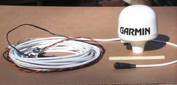
Garmin quotes an accuracy of 1-5m,
2DRMS. The unit draws 170ma. One must obtain a standard 1"x14
threads-per-inch marine mount for installation. A single 30-foot
cable is attached to the unit with a twist-lock connector. (A 60-foot
cable is also available). Five wires must be connected by the user
to 12vdc power, ground, NMEA 4800 baud serial to chart plotter or computer
input/output, and ON/OFF switch. GPS status and one pulse per second
(PPS with an accuracy of one microsecond) optional connections are also
available. The GPS doesn't have a data-storage capacity; this must
be provided by a computer and map program.
TESTING
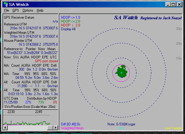
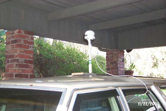
We soon discovered that surrounding trees
prevented getting useful data from an initial roof-mounted
installation. An SA Watch plot of the problem is shown (HERE).
This should also alert any who use GPS or DGPS, that a clear horizon is
essential to realizing the capability of any GPS.
We don't have a (floating) boat to test
this GPS rig on, so we equipped one with
four wheels!
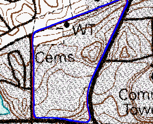
The first tests were to drive in a relatively
clear area around a clockwise course (FIVE times) in order to detect any
variation in accuracy from one loop to another. A Garmin G-III+ with
a GA-26 mag mount antenna was also used to record five tracks at
the same time as the G-53 tracks were being recorded by Ozi Explorer on
a USGS DRG map at a 2x zoom level (above). Later the G-III+ track
was downloaded to Ozi, so they could be compared on the same map.
The blue line is the G-III+ track which
overlies the red line of the G-53. It's interesting that on this
map scale (1:12,000) there is no discernible spread of the tracks of either
GPSs due to errors! Also there is no difference in the apparent accuracy
of either GPS except perhaps the western leg where the G-III+ seems to
be farther from the road line than the G-53. Driving on the RIGHT
side of the road is clearly evident. Thus the difference in GPS and
DGPS cannot be seen reliably on a map of this scale.
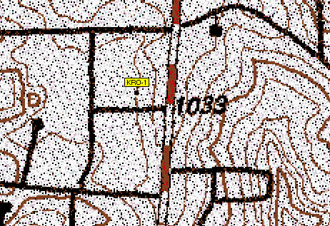
Next it was decided to move the test
station to a large open parking lot.
A DRG
map of the test location shows the station to be sitting on the 1,020-foot
contour line, plus 6 feet to the antenna (1,026 feet), or 313m antenna
altitude. First an SA Watch HDOP-weighted mean was obtained by three
hours recording of the G-53 position to establish a reference point.
The next day at the same time, another
3 hr. plot (above) was made to determine repeatability (if not absolute
accuracy). As indicated by the above SA Watch plot, the mean altitude
was 316m (a 3m error, data line 2), the mean position was 0.3m@222°
from the reference point (data line 4), and 95% of the data points fell
within 2.7m of the reference point (data line 9).
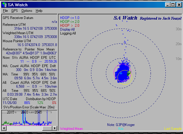
The next day at approximately the same
time, another 3-hr. plot (above) was recorded with a G-III+.
In this plot the mean altitude was 338m (a 25m error), the mean position
was 1.0m@063° from the reference point, and 95% of the data points
fell within 5.4m of the reference point. These GPS figures naturally
aren't as good as the DGPS figures. Note a few wild points to the
north. The DGPS system apparently is able to eliminate these types
of points, and in a safety situation could be very important.
The basic purpose of this GPS is to
provide an uncomplicated and accurate source of marine GPS navigation -which
it should do quite well.
Appendix:
NMEA Output Sentences
NMEA Input Sentences
$GPALM
$PGALM
$GPGGA
$PGRMI
$GPGSA
$PGRMC
$GPGSV
$PFRMO
$GPRMC
$PSLIB
$GPVTG
$PGRME
$PGRMT
$PGRMV
$PGRMF
$LCGLL
$LCVTG
Jack
Yeazel